place

Beaver Bridge (Ohio River)
1910 establishments in PennsylvaniaBridges completed in 1910Bridges in Beaver County, PennsylvaniaBridges over the Ohio RiverCSX Transportation bridges
Cantilever bridges in the United StatesHistoric American Engineering Record in PennsylvaniaPittsburgh and Lake Erie RailroadRailroad bridges in PennsylvaniaTruss bridges in the United States
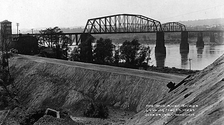
Beaver Bridge 1910
Beaver Bridge 1910

The Beaver Bridge is a rail bridge spanning the Ohio River between Monaca and Beaver, Pennsylvania. It consists of two spans: a southern cantilever through truss of 769 feet (234 m) with 320-foot (98 m) anchor arms; and a northern camelback through truss of 370 feet (110 m). The bridge currently carries two tracks of CSX Transportation. The bridge was designed by Albert Lucius and built by McClintic-Marshall Company of Pittsburgh between March 1908 and May 1910 for the Pittsburgh and Lake Erie Railroad. The bridge is notable in that the railroad proceeded with the cantilever design despite the collapse of the Quebec cantilever bridge during construction in 1907. The Beaver bridge replaced a single-track bridge built in 1890, 300 feet (91 m) downstream from the current bridge's position, which itself replaced an 1878 wrought iron bridge at the same location.

Excerpt from the Wikipedia article Beaver Bridge (Ohio River) (License: CC BY-SA 3.0, Authors, Images).

Beaver Bridge (Ohio River)
Atlantic Avenue,

Geographical coordinates (GPS) Address External links Nearby Places
placeShow on map

Wikipedia: Beaver Bridge (Ohio River)Continue reading on Wikipedia

Geographical coordinates (GPS)

Latitude Longitude
N 40.692906 ° E -80.290833 °
placeShow on map

Address

Beaver Bridge

Atlantic Avenue
15061
Pennsylvania, United States
mapOpen on Google Maps

linkWikiData (Q813469)
linkOpenStreetMap (831399410)

Beaver Bridge 1910
Beaver Bridge 1910
Share experience

Nearby Places

Beaver River (Pennsylvania)

Beaver River is a tributary of the Ohio River in Western Pennsylvania. Approximately 21 mi (34 km) long, it flows through a historically important coal-producing region north of Pittsburgh. The river is formed in Lawrence County by the confluence of the Mahoning and Shenango rivers in the Mahoningtown neighborhood of New Castle. It flows generally south, past West Pittsburg and Homewood, then receives Connoquenessing Creek west of Ellwood City and flows past Beaver Falls and New Brighton. It joins the Ohio at Bridgewater and Rochester (flowing between those towns) at the downstream end of a sharp bend in the Ohio approximately 20 mi (32 km) northwest of (and downstream from) Pittsburgh. In the lower reaches near the Ohio River, the Beaver cuts through a gorge of underlying sandstone. The river is roughly parallel to the border with the state of Ohio, with both Interstate 376 and Pennsylvania Route 18 running parallel to the river itself. The river, which flows throughout the northern half of Beaver County, is the namesake of the county as well as several locales in both Beaver and Lawrence County. The river itself was either named for King Beaver (Tamaqua) of the Delaware nation that had migrated to the area in the late 1740s, or for the animal. Until the partition of Lawrence County from parts of Beaver and Mercer County in 1849, the river was entirely in Beaver County, with its upstream terminus at the border between Beaver and Mercer County from 1800 to 1849.

Bridgewater Historic District (Bridgewater, Pennsylvania)

The Bridgewater Historic District is a historic district in Bridgewater, Pennsylvania, United States. Listed on the National Register of Historic Places on June 28, 1996, it includes buildings built between 1818 and 1933, although the most significant buildings in the district are those that were built before the Civil War in the 1860s. Located at the confluence of the Ohio and Beaver Rivers, Bridgewater was a transportation center as the terminus of the Bridgewater Canal during the pre–Civil War era. This prosperity is reflected in many of the district's buildings: the adjacent communities of Beaver and Rochester were less significant during that time, and accordingly have a much smaller number of period buildings.The district includes the Bridgewater-Rochester Bridge, a canal lock for the Bridgewater Canal, and 97 buildings. Among its contributing properties are three churches, the Keystone Bakery, and the William B. Dunlap Mansion, which is separately listed on the Register. Because the bridge spans the Beaver River to Rochester, a small portion of the district is located in Rochester. Another building in the district is the house of Joseph Hemphill, a local landowner who platted much of Bridgewater in 1818. Built in 1818, it is Bridgewater's oldest extant house.During Bridgewater's heyday, Bridge Street was a vibrant downtown street. Its buildings housed a wide variety of businesses, ranging from offices to stores to metalworking shops. Among the leading businesses of Bridge Street, the Keystone Bakery, was once the largest bakery in Western Pennsylvania outside of Pittsburgh and Allegheny. Now located on Market Street, Keystone left Bridge Street in 1884 because of its rapid expansion.The Bridgewater United Methodist Church was organized in 1839 and built its first building in the same year. Its current building, a Gothic Revival structure located on Market Street, was erected in 1907. First Presbyterian Church worships in a Romanesque Revival church at the western end of Bridge Street. The congregation was founded as the result of an 1845 split in the Presbyterian church in Rochester. Built in 1845 and remodelled several times since, the church remains in use to the present day.