place

Halifax School for the Deaf

History of Halifax, Nova ScotiaSchools for the deaf in Canada
MonumentSchooloftheDeafHalifaxNovaScotia

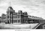
The Halifax School for the Deaf (The Deaf and Dumb Institution, Halifax) was an institution in Halifax, Nova Scotia, Canada, which opened on 4 August 1856. It was the first school of the deaf in Atlantic Canada. (The Halifax School for the Blind was opened on Morris Street in 1871.) There was later a dispute over who the true founder was, William Gray (1806-1881), a deaf Scottish immigrant who was the first teacher in the back room of a house in Argyle Street, or George Tait (1828-1904), another deaf Scot, who claimed to have been the driving force behind the establishment of the school. Gray was sacked in 1870 for being intoxicated and for threatening pupils with violence.The first principal of the school was James Scott Hutton, who remained with the school 34 years. William Cunard (son of Sir Samuel Cunard) eventually built a school, which was completed in 1896 and was attended by 90 students. Following the Halifax Explosion, the main building was temporarily closed for repairs. Half of the students attended classes on the campus of Acadia College in Wolfville, while others remained without education until the classes were relocated back to Halifax.The school closed in June 1961.A monument marks the location of the home, which was erected by the Eastern Canada Association of the Deaf.

Excerpt from the Wikipedia article Halifax School for the Deaf (License: CC BY-SA 3.0, Authors, Images).

Halifax School for the Deaf
Gottingen Street, Halifax Downtown Halifax

Geographical coordinates (GPS) Address Nearby Places
placeShow on map

Wikipedia: Halifax School for the DeafContinue reading on Wikipedia

Geographical coordinates (GPS)

Latitude Longitude
N 44.656014 ° E -63.58911 °
placeShow on map

Address

Victoria Hall

Gottingen Street 2438
B3K 3A9 Halifax, Downtown Halifax
Nova Scotia, Canada
mapOpen on Google Maps

MonumentSchooloftheDeafHalifaxNovaScotia
Share experience

Nearby Places

Morris House (Halifax, Nova Scotia)

Morris House (also known as the Morris Office) is the oldest wooden residence in Halifax, Nova Scotia (circa 1764) and the former office of Charles Morris (surveyor general). The house was originally located at 1273 Hollis Street, and since January 2013 has been located at 2500 Creighton Street. The Morris family used the house as their office for eighty years. There were four generations of the Morris family, a dynasty of Surveyor Generals of Nova Scotia, who used the building as their office. Due to the efforts of the Heritage Trust of Nova Scotia and others, the house has been salvaged from demolition in 2009. The original property was owned by Dennis Heffernan who sold it to Charles Morris Jr. in 1777, who likely had his father stay with him. A Raman spectroscopic chemical analysis study at Saint Mary's University revealed that the interior paints and wallpaper contained 19th century inorganic pigments such as basic lead carbonate (white lead), lead carbonate, barium sulfate, calcium carbonate (chalk), and chromium(III) oxide (chrome green). The exterior was painted with a modern synthetic pigment, copper phthalocyanine (Phthalocyanine Blue BN). Local design firm Breakhouse partnered with eyecandy SIGNS INC. to design and build the monument sign that honours the life and home of Charles Morris. The sign is installed at the original location of the house. The house has been moved to Charles St in the North End of Halifax.

Robie Street
Robie Street

Robie Street is a north-south artery that runs for 7 km in the Halifax Peninsula area of the Halifax Regional Municipality, from Memorial Drive in the North End Halifax, to Gorsebrook Avenue in the South End. The street and provincial road has in most places four lanes, with a centre median from Gorsebrook Avenue to Cunard Street. From Cunard to Almon Streets, it has two lanes. From Livingstone Street to Memorial Drive, it has two lanes lane street. From Almon Street to the MacKay Bridge ramps, it has four lanes and is undivided. Massachusetts Avenue (until May 21, 2007, it was, and commonly still is, referred to as Robie Street Extension) connects Robie Street from Livingstone Street to the MacKay Bridge. On the Halifax Peninsula street grid system, civic numbers range from 820 to 3899.The street was named after Simon Bradstreet Robie (1770–1858), a prominent Nova Scotia judge and politician. There are also streets named after Judge Robie in Truro and Amherst, Nova Scotia. Prior to circa 1910, Robie Street ended at North Street, with the continuation of the road to the north being part of Kempt Road, and continuing further north from Young Street as Lonegard Road. At first, Robie was mainly a residential and commercial street, but in 1882, the Nova Scotia Cotton Manufacturing Company was constructed at the intersection with Almon Street, which was followed by a series of other factories and created an industrial distinct at the north end of Robie.

Royal Navy Burying Ground (Halifax, Nova Scotia)

The Royal Navy Burying Ground is part of the Naval Museum of Halifax and was the Naval Hospital cemetery for the North America and West Indies Station at Halifax, Nova Scotia. It is the oldest military burial ground in Canada. The cemetery has grave markers to those who died while serving at Halifax and were treated at the Naval medical facility or died at sea. Often shipmates and officers had the grave markers erected to mark the deaths of the crew members who died while in the port of Halifax. The number of burials is estimated at over 400, however, there are only 89 stone markers remaining. There was a register of deaths established in 1860 for the burial ground. As well, surgeons of a ship registered the deaths of crew members, including how the person died and where they were buried. These reports were entered in the official register, with a detailed account sent quarterly to the Medical Director-General, Admiralty, England. There is no local record of who is buried. The four most common causes of death in order are: disease, falling from the topmast, drowning, and death as a result of naval battles. Along with two monuments that commemorate casualties of the War of 1812, the most prominent markers are for the crew that died on the flagships of the North American and West Indies Station: HMS Winchester (1841), HMS Wellesley (1850), HMS Cumberland (1852), HMS Indus (1859), HMS Nile (1861), HMS Duncan (1866), and HMS Royal Alfred (1869). There were many buried during the wars of the 18th century (American Revolution, French Revolutionary War and Napoleonic Wars) that do not have grave markers.