place

Echt, Aberdeenshire

Aberdeenshire geography stubsVillages in Aberdeenshire
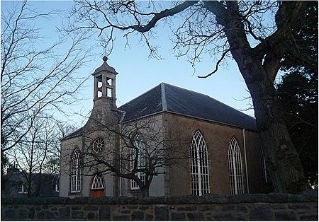
Echt church
Echt church

Echt (Scottish Gaelic: Eicht) is an Aberdeenshire crossroads village in northeast Scotland with a population of approximately 300 people. Echt has a number of prehistoric remains, including the Barmekin of Echt which is on a hill to the northwest. There is also the Cullerlie stone circle near Sunhoney Farm, which may date from the Bronze Age.Echt contains a church, village shop/post office, restaurant (Echt Tandoori) and pleasure park with a designated area of children's play equipment and local football matches are held. The annual Echt Show, a farmers' show, is held on the 2nd Saturday in July. It is centred on the junction of the B977 Dunecht—Banchory road and the B9119 Kingsford—Ordie road. It is some 12+1⁄2 miles (20.1 km) from the city of Aberdeen.

Excerpt from the Wikipedia article Echt, Aberdeenshire (License: CC BY-SA 3.0, Authors, Images).

Echt, Aberdeenshire
Orchard Grove,

Geographical coordinates (GPS) Address Nearby Places
placeShow on map

Wikipedia: Echt, AberdeenshireContinue reading on Wikipedia

Geographical coordinates (GPS)

Latitude Longitude
N 57.14054 ° E -2.43455 °
placeShow on map

Address

Orchard Grove
AB32 7AG
Scotland, United Kingdom
mapOpen on Google Maps

Echt church
Echt church
Share experience

Nearby Places

Cullerlie stone circle

Cullerlie stone circle, also known as the Standing Stones of Echt, is a small stone circle situated near Echt, Aberdeenshire. It consists of eight irregular stones of red granite arranged at approximately equal intervals to form a circle of 10.2 m (33 ft) diameter, enclosing the same number of small cairns. The cairns are characterised by outer kerbs or rings of stones, with a double ring surrounding the central cairn and a single ring in the others. All but one of the cairns have eleven ringstones, with the last having nine. The whole circle sits on a patch of gravel which forms the end of a low gravel ridge linking the site with Leuchar Moss. It is regarded as "a later development from the recumbent stone circle", though its layout with kerbed cairns within the circle makes it unique. At the time that the circle was built in the second millennium BC, the surrounding landscape was characterised by wet bogs, and the stones were transported to the site from higher ground some distance away. The tallest of the stones marks the north side of the circle. They vary in height from 1.09 m (3.6 ft) to 1.80 m (5.9 ft). A 2004 survey of the site discovered that several of the stones had been carved with previously unnoticed cup marks.Excavations carried out in 1934 by H. E. Kilbride-Jones on behalf of the Ministry of Works, showed that the circle was built in stages. The entire site had first been cleared, leveled and burned by setting fire to piles of willow twigs. Then came the outer stones, with their bases shaped into points to make them more stable in their gravel bed. They have been somewhat eroded over time by acidic peat eating away the lower portions of the stones. Oak and hazel were burned within the stone rings, leaving charcoal behind, and cremated human bones were deposited in the ashes within five of the rings. They were then filled with smaller stones to create the cairns visible today.The circle may once have had several companions. In 1820 James Logan wrote: "The small Circles contained in the larger present a curious singularity; and it is also remarkable that, at a short distance to the southwest, are nine others of similar dimensions." However, when the site was excavated in 1934, no trace of these satellite circles could be found.