place

Bellshill railway station

BellshillFormer Caledonian Railway stationsPages with no open date in Infobox stationRailway stations in Great Britain opened in 1879Railway stations in North Lanarkshire
Railway stations served by ScotRailSPT railway stationsScotland railway station stubs
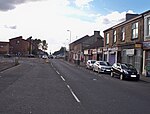
Bellshill railway station in 2008

Bellshill railway station is a railway station in the town of Bellshill, North Lanarkshire, Scotland. The station is managed by ScotRail and served by Argyle Line and Shotts Line services. The station is adjacent to Bellshill Main Street, on Hamilton Road, and was opened by the Caledonian Railway as part of the Cleland and Midcalder Line on 1 May 1879. West of the station, the Glasgow, Bothwell, Hamilton and Coatbridge Railway crossed with a second station in the town to the north west - this ceased to carry passengers back in 1951. The line through the station was electrified as part of the 1974 West Coast Main Line project. Although it is situated east of the Shotts Line's junction with the WCML south of Uddingston, electric trains can reach Motherwell using a chord line to the route from Coatbridge Central and Mossend which passes beneath the Shotts route east of the station (these lines being wired to allow electric access to the yard at Mossend and to allow goods trains to avoid the busy Motherwell area).

Excerpt from the Wikipedia article Bellshill railway station (License: CC BY-SA 3.0, Authors, Images).

Bellshill railway station
Elmbank Street,

Geographical coordinates (GPS) Address External links Nearby Places
placeShow on map

Wikipedia: Bellshill railway stationContinue reading on Wikipedia

Geographical coordinates (GPS)

Latitude Longitude
N 55.8171 ° E -4.0243 °
placeShow on map

Address

Bellshill

Elmbank Street
ML4 2DZ , Orbiston
Scotland, United Kingdom
mapOpen on Google Maps

linkWikiData (Q2349644)
linkOpenStreetMap (2958494672)

Bellshill railway station in 2008
Share experience

Nearby Places

Strathclyde Country Park

Strathclyde Country Park is a country park located on the outskirts of Motherwell in North Lanarkshire, Scotland, named after the former Strathclyde region of Scotland. It is often commonly referred to as Strathclyde, or simply Strathy. The park covers some 4 km2 (1.5 sq mi), centred on the artificial Strathclyde Loch. It is located next to the River Clyde between Hamilton and Motherwell. Strathclyde Park forms what used to be known as the Low Parks of the now demolished Hamilton Palace and still includes buildings associated with the palace. When the loch was created in the early 1970s it involved the flooding of the old mining village of Bothwellhaugh. The park offers many amenities and attractions such as coarse angling, woodland walks, watersports, and a camping and caravanning site. One of Scotland's theme parks, M&D's, is located in the park. Until 1996, the music festival T in the Park was held here. The west side of the park is bounded by the River Clyde, which was diverted when the loch was built in 1975. The original course can be seen between the east loch shore and the island. Across the Clyde is the M74 motorway, which creates a significant level of noise. The east side of the park is quieter, with woodland and paths leading up the slopes to Motherwell. The remains of Bothwellhaugh Roman Fort and a Roman bathhouse can be seen in the park, where the South Calder Water flows into the loch. There is an arched Roman bridge across the South Calder nearby. The site of the Battle of Bothwell Bridge (1679) is to the north west of the park. Although the focus of the park is on recreation, a variety of habitats are present, including wetlands and native woodland. The Greenlink Cycle Path start-off point is located in the park and travels to Motherwell Town Centre. Also, a section of the Clyde walkway, from Glasgow to New Lanark, runs through the park.