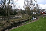
Wandle Meadow Nature Park

Wandle Meadow Nature Park is a 4.15 hectare local nature reserve and Site of Borough Importance for Nature Conservation, Grade 1, in Wimbledon in the London Borough of Merton. It is owned and managed by Merton Council.A map of 1847 shows the site as Byegrove Mead, which may have been managed as water meadows. In 1877 it was acquired by a sewage company, and it formed part of a sewage works until this closed in 1970. A plan to build a stadium for Wimbledon Football Club on the site was strongly opposed by local residents, and in 1989 it was designated as a nature reserve by Merton Council.The Meadow lies between the River Wandle and Mead Path, part of the Wandle Trail. Wetland plants and animals include small sweet-grass, eared willow and broad-bodied chaser dragonflies. Bullfinches, whitethroats and reed buntings breed in woodland areas. There are also bodies of water which have a variety of frogs, toads and newts.The Nature Reserve is accessible via Chaucer Way, Boundary Road & North Road in Colliers Wood, a footbridge across the River Wandle from Garfield Road Recreation Ground in South Wimbledon and from a footpath at Plough Lane, Wimbledon.
Excerpt from the Wikipedia article Wandle Meadow Nature Park (License: CC BY-SA 3.0, Authors, Images).Wandle Meadow Nature Park
Wandle Trail, London Collier's Wood (London Borough of Merton)
Geographical coordinates (GPS) Address Nearby Places Show on map
Geographical coordinates (GPS)
| Latitude | Longitude |
|---|---|
| N 51.424 ° | E -0.183 ° |
Address
Haydons Road Track Paralleling Hut
Wandle Trail
SW19 1UH London, Collier's Wood (London Borough of Merton)
England, United Kingdom
Open on Google Maps


