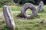
West Lanyon Quoit
Dolmens in CornwallPenwith

West Lanyon Quoit, also known as Lower Lanyon Quoit, is the remains of a prehistoric dolmen situated in the parish of Madron in Cornwall grid reference SW423337. It was excavated in the late 18th century, and much of the structure has since been destroyed.
Excerpt from the Wikipedia article West Lanyon Quoit (License: CC BY-SA 3.0, Authors, Images).West Lanyon Quoit
Bosullow Vean,
Geographical coordinates (GPS) Address External links Nearby Places Show on map
Geographical coordinates (GPS)
| Latitude | Longitude |
|---|---|
| N 50.147703 ° | E -5.607821 ° |
Address
Bosullow Vean
TR20 8NS , Madron
England, United Kingdom
Open on Google Maps


