place

South New Brighton

Suburbs of ChristchurchUse New Zealand English from October 2021
Damaged pier South New Brighton Park

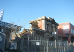
South New Brighton is a coastal suburb on the eastern side of Christchurch city. The suburb was officially named in 1953, after a suggestion that it be called South Brighton was rejected because there is already Brighton near Dunedin.South Brighton Community Hall opened in 1961. It was damaged by the 2010-2011 earthquakes and demolished. In 2013, a preschool building was moved from QEII Park to the site as a replacement.

Excerpt from the Wikipedia article South New Brighton (License: CC BY-SA 3.0, Authors, Images).

South New Brighton
Pine Avenue, Christchurch South New Brighton (Coastal-Burwood Community)

Geographical coordinates (GPS) Address Nearby Places
placeShow on map

Wikipedia: South New BrightonContinue reading on Wikipedia

Geographical coordinates (GPS)

Latitude Longitude
N -43.53 ° E 172.737 °
placeShow on map

Address

Pine Avenue 256
8062 Christchurch, South New Brighton (Coastal-Burwood Community)
Canterbury, New Zealand
mapOpen on Google Maps

Damaged pier South New Brighton Park
Share experience

Nearby Places

Clifton, Christchurch

Clifton is a hillside suburb above Sumner in Christchurch, New Zealand. Clifton is a volcanic spur extending from Tauhinukorokio / Mount Pleasant. Most of Clifton was originally purchased by Dr Alfred Barker, who had applied for a 50 acres (20 ha) land grant from the Christchurch land office. Barker sold his land in 1872. The lower part of Clifton was undeveloped until 1903, when it was subdivided into 93 sections and put up for auction, as far up the hill as Tuawera Terrace, which was originally known as Victoria Terrace. The land further up the hill was subdivided in 1908. A lower side spur, originally known as Lower Clifton, was bought in 1901 by Samuel Hurst Seager. Seager landscaped and divided the section into 12 plots and it was sold under the name The Spur in 1914. It has been known as the Spur since. This area is the main residential hill area above Sumner.The ridge that Clifton lies upon, descends from Tauhinukorokio / Mount Pleasant to end in a coastal cliff at the western end of Sumner beach. The cliff overhangs the road between Sumner and Moncks Bay that has been built along the beach. This area by the beach is now known as Peacocks Gallop because John Thomas Peacock would gallop his horse when riding along this section of road on account of his fear of being hit by falling rocks. Earthquakes in 2011 and later in 2016 caused the cliff edge to collapse and recede so much that several clifftop houses were undermined and severely damaged, or left perched precariously on the cliff edge. Shipping containers were stacked two-high on the main road below to protect it from further rockfalls and these subsequently became an impromptu roadside art gallery.