place

Tampere Lenin Museum

European museum stubsFinland–Soviet Union relationsFinnish building and structure stubsMonuments and memorials to Vladimir LeninMuseums in Tampere
Recipients of the Order of Friendship of Peoples
Lenin museum 1
Lenin museum 1

The Tampere Lenin Museum (Finnish: Lenin-museo) is a museum devoted to Vladimir Lenin in Tampere, Finland. It was established in 1946 by the Finland–Soviet Union Society, and today it is run by The Finnish Labour Museum Werstas. It was the first museum dedicated to Lenin outside the Soviet Union, and is now the only surviving one located outside Russia. The museum is located in the Tampere Workers' Hall. Built in 1900, the building hosted underground meetings of the Russian Social Democratic Labour Party in 1905 and 1906. At the 1905 meeting, Lenin met Joseph Stalin in person for the first time. The museum has a permanent exhibition with material related to Lenin's life and the history of the Soviet Union. It also organizes varying exhibitions on different themes.The museum was awarded the Order of Friendship of Peoples in 1986 by the council of Supreme Soviet of the Soviet Union. Since the collapse of the Soviet Union, the museum has developed a more critical view to Lenin's work and the Soviet Union.

Excerpt from the Wikipedia article Tampere Lenin Museum (License: CC BY-SA 3.0, Authors, Images).

Tampere Lenin Museum
Hallituskatu, Tampere Kaakinmaa (Keskustan suuralue)

Geographical coordinates (GPS) Address Nearby Places
placeShow on map

Wikipedia: Tampere Lenin MuseumContinue reading on Wikipedia

Geographical coordinates (GPS)

Latitude Longitude
N 61.495714 ° E 23.752026 °
placeShow on map

Address

Hallituskatu 19
33200 Tampere, Kaakinmaa (Keskustan suuralue)
Finland
mapOpen on Google Maps

Lenin museum 1
Lenin museum 1
Share experience

Nearby Places

Kaakinmaa
Kaakinmaa

Kaakinmaa is a district in Tampere, Finland, located in the city center. It includes the area south of Pyynikki Church Park (Pyynikin kirkkopuisto) between the Hämeenpuisto park and the Mariankatu street. To the south, the area extends to Eteläpuisto on the shores of Lake Pyhäjärvi. The neighboring parts of the city are Nalkala in the east, Amuri in the north and Pyynikki and Pyynikinrinne in the west. Sometimes Kaakinmaa is incorrectly considered to belong to Pyynikki and Pyynikinrinne; however, Kaakinmaa has its own district. The most important street running through the area is Satamakatu, which rises west of the slope of Pyynikinharju from Laukontori, which together with Mariankatu and Hämeenpuisto form a busy traffic route from Pyynikintori to Ratina. Along the Koulukatu street there is the Koulukatu Field, where the hockey field and ice rink are frozen in winter. 
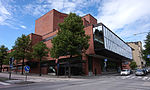
In Kaakinmaa, the Tampere Workers' Hall and the Tampere Workers' Theatre are located, as well as the old Pyynikki Brewery and the Klingendahl factory property. Next door to Klingendahl is the former Tampere Epidemic Hospital, built in 1910, which was used as a student dormitory until the summer of 2009 after the hospital closed. Almost all of the residential buildings in the area are apartment buildings, built mainly in the 1960s and 1970s to replace the earlier wooden houses built in the late 19th century. The primary schools operating in Kaakinmaa are the Alexander School of the 1st–6th grades and the Pyynikki School of the 7th–9th grades (former Tampere High School for Girls). At the corner of Satamakatu and Koulukatu is the Swedish-language school (Svenska samskolan i Tammerfors), which includes grades 1-9 of the comprehensive school and the upper secondary school. A brewery has previously operated in Kaakinmaa. In 1897, a brewery was established on the corner of Tiilitehtaankatu and Papinkatu, which later became Oy Pyynikki. In 1903, another brewery operating in Tampere, Oy Iso Oluttehdas, and Oy Pyynikki merged to form Näsijärven Osake-Oluttehdas, which in 1920 took the name Oy Pyynikki Ab. Until 1992, Pyynikin Brewery produced the Amiraali beer brand, which is popular with the local population and is still available in Japan with a label with the image of Admiral Tōgō Heihachirō (1848–1934) from the Tupgō flagship Mikasa's museum store in Yokosuka. The brewing business in Tampere was discontinued soon after Pyynikki Oy came under Sinebrychoff. The same fate in the hands of Sinebrychoff was later experienced by the Pori Brewery. In 2012, the Pyynikki craft brewery was established in Tampere to continue the tradition of the Pyynikki brewery, although for the time being, due to the lack of suitable premises, it operates in Rahola. The name of Kaakinmaa derives from the kaakinpuu tree, also known as pillory, used to punish evildoers on the site of Tampere's co-educational high school until the second half of the 19th century. After the settlement of Kaakinmaa, the kaakinpuu tree was transferred to a sand pit along the current Pirkankatu, where it was located until the new penalty law abolished cropping in 1894. The town plan for Kaakinmaa was completed in 1868. In 1870, the area of Kaakinmaa was still uninhabited, but twenty years later there were already about a thousand inhabitants. At the beginning of the 20th century, the inhabitants of Kaakinmaa were mainly engaged in various professions.On the western side of Kaakinmaa, along Mariankatu, in 1936–1973, there was a Christmas Sign Home owned by the Finnish Tuberculosis Resistance Association (Filha ry), which cared for the newborn children of mothers with tuberculosis. After the operation of the nursing home ended, the building was demolished and there is now an apartment building on its site.

Satakunnankatu
Satakunnankatu

Satakunnankatu is an east–west, busy street in the center of Tampere, Finland, which is one of the city's main streets. It starts from the vicinity of Tampere Cathedral on the east side of Tammerkoski, where it separates the Jussinkylä and Kyttälä Districts. The street crosses the rapids along the Satakunta Bridge (Satakunnansilta) and runs on the west side between Finlayson and the Hämeenpuisto park. From there it continues through the Amuri area to the Pirkankatu street.Satakunnankatu is part of the nationally significant industrial landscape of Tammerkoski, and there are several sites along it that are valuable for architecture, cultural history and the cityscape. The street is bordered by, among other things, the former weaving building Plevna (1877), which belongs to the Finlayson factory area, where the first electric lighting in the Nordic countries and the then Russian Empire was introduced in 1882. Other nationally significant buildings on Satakunnankatu include the Central Fire Station designed by Wivi Lönn (1907) and the Hotel Tammer (1928) designed by Bertel Strömmer.The current street name Satakunnankatu (meaning "Satakunta Street") was marked in the Tampere's town plan in 1907. However, the history of the street is older. Initially, there have been two streets with different names, Uusikatu ("New Street") and Uudensillankatu ("New Bridge Street"), which the Tammerkoski rapids has separated from each other.: 61, 64 The first and oldest part of the street is located in the area which nowadays stretches from Aleksis Kiven katu to Näsilinnankatu. This area, west of the rapids, was designed by geographic surveyor Daniel Hall (1739–1803) in 1775. Hall's plan later became Tampere's first zoning plan, taking effect in 1779.: 61 : 26, 28–29, 33  On the first city maps of Tampere the streets had no names. The name Uusikatu was invented by a committee appointed in 1807 to name the streets. The name was entered into the map in the 1820s when the geographic surveyor Johan Wallenius (1765–1849) was designing a new zoning plan. Wallenius used the Swedish language name Ny Gatan for the street. On his map the street had grown in length to the west and reached Kortelahdenkatu (at that time named Brahe Lång Gatan or Brahen Pitkäkatu). Uusikatu became the street's official name in 1868.: 17–18, 61–62, 64 : 54, 59  The street was repeatedly lengthened to the west, and because of heightened fire safety after the Tampere fire of 1865 it was partly widened as a boulevard.: 76–77, 79, 86–87, 90–91 The eastern side of the rapids was connected to Tampere from the parish of Messukylä in 1877. The city architect F. L. Calonius made a town plan for the area, where the main eastern part of Satakunnankatu was the main frame street. The name of the street first appeared in the draft town plan (1879) in the form Uudensillankatu. The name Uudensillankatu was officialized in 1886. Uusisilta referred to the Satakunta Bridge, which was built only later, in 1897–1900.: 19, 80, 84–85 : 87–88  The Satakunta Bridge apparently caused the decision to change Uusikatu and Uudensillankatu to Satakunnankatu in the 1907 town plan change.: 84