place

Newport built-up area

Demographics of WalesGeography of Newport, WalesUrban areas of WalesUse British English from August 2019
NewportBuiltUpArea
NewportBuiltUpArea

The Newport Built-up area (previously known in official statistics as the Newport Urban Area) is an area of land defined by the United Kingdom Office for National Statistics (ONS) for population monitoring purposes. It is an urban conurbation and is not coterminous with the city boundaries. It consists of the urban area centred on Newport as well as contiguous settlements in the eastern and western valleys extending north of the city – including Cwmbran, Pontypool, Risca, Abercarn and Blackwood. It does however exclude physically detached urban areas within the city boundaries, such as Marshfield. The detailed methodology of the process used across the UK by ONS in 2011 is set out in 2011 Built-up Areas - Methodology and Guidance, published in June 2013. It is summarised as "..a ‘bricks and mortar’ approach, with areas defined as built-up land with a minimum area of 20 hectares (0.2 km2 / 0.077 mile2), while settlements within 200 metres of each other are linked. Built-up area sub-divisions are also identified to provide greater detail in the data, especially in the larger conurbations."The total population of the built-up area defined on this basis in 2011 was 306,844, making Newport the 23rd largest conurbation in England and Wales and the 2nd largest in Wales.

Excerpt from the Wikipedia article Newport built-up area (License: CC BY-SA 3.0, Authors, Images).

Newport built-up area
St Woolos Road, Newport St. Woolos

Geographical coordinates (GPS) Address Nearby Places
placeShow on map

Wikipedia: Newport built-up areaContinue reading on Wikipedia

Geographical coordinates (GPS)

Latitude Longitude
N 51.583333333333 ° E -3 °
placeShow on map

Address

St Woolos Road 23
NP20 4GN Newport, St. Woolos
Wales, United Kingdom
mapOpen on Google Maps

NewportBuiltUpArea
NewportBuiltUpArea
Share experience

Nearby Places

Newport, Wales
Newport, Wales

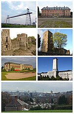
Newport (Welsh: Casnewydd; [kasˈnɛwɨð]) is a city and county borough in Wales, situated on the River Usk close to its confluence with the Severn Estuary, 12 mi (19 km) northeast of Cardiff. With a population of 145,700 at the 2011 census, Newport is the third-largest principal authority with city status in Wales, and seventh most populous overall. Newport became a unitary authority in 1996 and forms part of the Cardiff-Newport metropolitan area, also known as the Cardiff Capital Region. Newport was the site of the last large-scale armed insurrection in Great Britain, the Newport Rising of 1839. The population grew considerably between the 2011 and the 2021 census, rising to 159,587, the largest growth of any unitary authority in Wales. Newport has been a port since medieval times when the first Newport Castle was built by the Normans. The town outgrew the earlier Roman town of Caerleon, immediately upstream and now part of the city. Newport gained its first charter in 1314. It grew significantly in the 19th century when its port became the focus of coal exports from the eastern South Wales Valleys. Newport was the largest coal exporter in Wales until the rise of Cardiff in the mid-1800s. In the 20th century, the docks declined in importance, but Newport remained an important centre for manufacturing and engineering. Latterly its economy has been bolstered as part of the M4 corridor high-technology cluster. It was granted city status in 2002. The Celtic Manor Resort in Newport hosted the Ryder Cup in 2010 and was the venue for the 2014 NATO summit. The city contains extensive rural areas surrounding the built-up core. Its villages are of considerable archaeological importance. Newport Cathedral is the seat of the Anglican Bishop of Monmouth and is the cathedral of the Diocese of Monmouth.