place

Cappahosic House

1751 establishments in VirginiaArchaeological sites on the National Register of Historic Places in VirginiaGeorgian architecture in VirginiaGloucester County, Virginia geography stubsHistoric American Buildings Survey in Virginia
Houses completed in 1751Houses in Gloucester County, VirginiaHouses on the National Register of Historic Places in VirginiaMiddle Peninsula Registered Historic Place stubsNational Register of Historic Places in Gloucester County, VirginiaUse mdy dates from August 2023
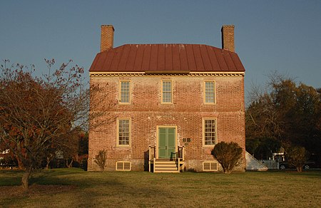
CAPPAHOSIC HOUSE
CAPPAHOSIC HOUSE

Cappahosic House, also known as Baytop House and Cappahosic Ferry House, is a historic home located near Gloucester, Gloucester County, Virginia. It was built in around 1751, and is a two-story, three bay brick dwelling in the Georgian style. It has a basement and is topped by a standing seam jerkinhead red tin roof. The main block is connected in the rear to a two-story modern addition. Also on the property are contributing archaeological deposits dating principally to the 18th and 19th centuries. The house is believed to be on the site of an 18th-century ferry used to cross the York River.It was added to the National Register of Historic Places in 2003.

Excerpt from the Wikipedia article Cappahosic House (License: CC BY-SA 3.0, Authors, Images).

Cappahosic House
Cappahosic Road,

Geographical coordinates (GPS) Address Nearby Places
placeShow on map

Wikipedia: Cappahosic HouseContinue reading on Wikipedia

Geographical coordinates (GPS)

Latitude Longitude
N 37.380277777778 ° E -76.633333333333 °
placeShow on map

Address

Cappahosic Road 3184
23061
Virginia, United States
mapOpen on Google Maps

CAPPAHOSIC HOUSE
CAPPAHOSIC HOUSE
Share experience

Nearby Places

Werowocomoco
Werowocomoco

Werowocomoco was a village that served as the headquarters of Chief Powhatan, a Virginia Algonquian political and spiritual leader when the English founded Jamestown in 1607. The name Werowocomoco comes from the Powhatan werowans (weroance), meaning "leader" in English; and komakah (-comoco), "settlement". The town was documented by English settlers in 1608 as located near the north bank of the York River in what is now Gloucester County. It was separated by that river and the narrow Virginia Peninsula from the English settlement of Jamestown, located on the James River. Powhatan's Chimney at Wicomico, a site of historical ruins associated with a house purported to have been built for Powhatan, was long thought to have been the site of this capital. Its probable true site was tentatively identified by archaeologists in 2003 at a site on Purtan Bay, further west on the York River. Their survey and excavations revealed extensive artifacts, with habitation from the 13th into the 17th century. Its first settlement was dated about 1270 CE, with complex earthworks built about 1400 CE. The area that the Native Americans considered Werowocomoco may have included both the newly identified Purtan Bay site and the site of Powhatan's Chimney site. The Gloucester County Board of Supervisors noted that in the Algonquian language the designation for the village of the chief was not a place name, but more correctly translated as a reference to the lands where he lived. The culture frequently relocated quarters within a general area.

Bigler's Mill, Virginia

Bigler's Mill was a small town in Virginia near Williamsburg in York County which is now extinct. It is considered one of the many lost towns of Virginia. The original community on this site was founded by James Bigler in the spring of 1852, who purchased 2400 acres of timberland, part of the tract known as Rippon Hall. He built a sawmill and gristmill with a long pier extending into the York River. A series of homes, a store and church were also constructed. During the Peninsula Campaign of the Civil War, the property was occupied by Confederate forces; in May 1862, Federal gunboats shelled the mill and set fire to the buildings and the pier, for which Bigler was later compensated.After the war, a new community grew up along the river based on oyster planting and harvesting. In this practice, seed oysters were gathered from rocky river bottoms, mostly in the James River, and planted in the muddier York River. The right to plant and harvest sections of the riverbed was leased from the state, and leaseholds were transferable, a system that provided some measure of protection from overfishing, and prosperity for the lease owners. During World War II, the U.S. Navy took over a large area in the north-western portion of York County, which was developed as Camp Peary. All residents of the entire towns of Bigler's Mill and nearby Magruder were removed, and many of the areas were redeveloped. Camp Peary later became well known as "The Farm," a training facility for the U.S. Central Intelligence Agency (CIA). Access to the base is restricted. The 100-acre (400,000 m2) Biglers Millpond occupies the site adjacent to the York River.