place

Hebron

13 Kohanic cities4th-millennium BC establishmentsBronze Age sites in the State of PalestineCanaanite citiesCities in the West Bank
Cities of refugeFormer national capitalsHebrew Bible citiesHebronHebron GovernorateHistoric Jewish communitiesHoly citiesHoly cities of JudaismMunicipalities of the State of PalestinePopulated places established in the 4th millennium BCTorah citiesWikipedia extended-confirmed-protected pages
Hebron172
Hebron172

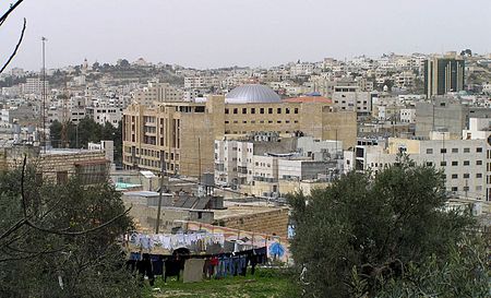
Hebron (Arabic: الخليل al-Khalīl, or خَلِيل الرَّحْمَن Khalīl al-Raḥmān; Hebrew: חֶבְרוֹן Ḥevrōn, ) is a Palestinian city in the southern West Bank, 30 kilometres (19 mi) south of Jerusalem. Nestled in the Judaean Mountains, it lies 930 metres (3,050 ft) above sea level. The second-largest city in the West Bank (after East Jerusalem), and the third-largest in the Palestinian territories (after East Jerusalem and Gaza), it had a population of 201,063 Palestinians in 2017, and seven hundred Jewish settlers concentrated on the outskirts of its Old City. It includes the Cave of the Patriarchs, which Jewish, Christian, and Islamic traditions all designate as the burial site of three key patriarchal/matriarchal couples. The city is often considered one of the four holy cities in Judaism as well as in Islam.Hebron is considered one of the oldest cities in the Levant. According to the Bible, Abraham settled in Hebron and bought the Cave of the Patriarchs as a burial place for his wife Sarah. Biblical tradition holds that the patriarchs Abraham, Isaac, and Jacob, along with their wives Sarah, Rebecca, and Leah, were buried in the cave. Hebron is also recognized in the Bible as the place where David was anointed king of Israel. Following the Babylonian captivity, the Edomites settled in Hebron. During the first century BCE, Herod the Great built the wall which still surrounds the Cave of the Patriarchs, which later became a church, and then a mosque. With the exception of a brief Crusader control, successive Muslim dynasties ruled Hebron from the 6th century CE until the Ottoman Empire's dissolution following World War I, when the city became part of British Mandatory Palestine. A massacre in 1929 and the Arab uprising of 1936–39 led to the emigration of the Jewish community from Hebron. The 1948 Arab–Israeli War saw the entire West Bank, including Hebron, occupied and annexed by Jordan, and since the 1967 Six-Day War, the city has been under Israeli military occupation. Following Israeli occupation, Jewish presence was reestablished at the city. Since the 1997 Hebron Protocol, most of Hebron has been governed by the Palestinian National Authority. The city is often described as a "microcosm" of the Israeli-Palestinian conflict and the Israeli occupation of the West Bank. The Hebron Protocol of 1997 divided the city into two sectors: H1, controlled by the Palestinian National Authority, and H2, roughly 20% of the city, including 35,000 Palestinians, under Israeli military administration. All security arrangements and travel permits for local residents are coordinated between the Palestinian National Authority and Israel via the Israeli military administration of the West Bank (COGAT). The Jewish settlers have their own governing municipal body, the Committee of the Jewish Community of Hebron. Today, Hebron is the capital of the Hebron Governorate, the largest governorate of the State of Palestine, with an estimated population of around 782,227 as of 2021. It is a busy hub of West Bank trade, generating roughly a third of the area's gross domestic product, largely due to the sale of limestone from quarries in its area. It has a local reputation for its grapes, figs, limestone, pottery workshops and glassblowing factories. The old city of Hebron features narrow, winding streets, flat-roofed stone houses, and old bazaars. The city is home to Hebron University and the Palestine Polytechnic University.

Excerpt from the Wikipedia article Hebron (License: CC BY-SA 3.0, Authors, Images).

Hebron
Jerusalem Rd., Hebron Old City

Geographical coordinates (GPS) Address Nearby Places
placeShow on map

Wikipedia: HebronContinue reading on Wikipedia

Geographical coordinates (GPS)

Latitude Longitude
N 31.528611111111 ° E 35.096944444444 °
placeShow on map

Address

شارع الملك عبد الله

Jerusalem Rd.
150 Hebron, Old City
Palestinian Territories
mapOpen on Google Maps

Hebron172
Hebron172
Share experience

Nearby Places

Old Jewish cemetery, Hebron

The old Jewish cemetery in Hebron, is located to the west of the Tomb of Machpela on a hill and has been used as a Jewish cemetery for hundreds of years, as attested to by Ishtori Haparchi, who noted a Jewish cemetery in the area in 1322. Other sources indicate the cemetery being mentioned in a letter dated to 1290. Among the prominent rabbinical sages and community figures buried in the cemetery include Rabbi Eliyahu de Vidas known as the Reshit Hokhma, Rabbi Abraham Azulai, Rabbi Solomon Adeni, Rabbi Elijah Mizrachi, Rabbi Chaim Hezekiah Medini known as the Sdei Chemed, Rabbi Judah Bibas, Rabbi Haim Rahamim Yosef Franco, Rabbi Hillel Moshe Gelbstein, Rabbi Shimon Menashe Chaikin, and Menucha Rochel Slonim. Menachem Mendel of Kamenitz, the first hotelier in the Land of Israel, references his visit to the grave of Eliyahu de Vidas in his 1839 book Sefer Korot Ha-Itim. He states, "here I write of the graves of the righteous to which I paid my respects." After describing the Cave of Machpela and the tombs of such Biblical figures as Ruth and Jesse, Othniel Ben Knaz and Abner Ben Ner, he reports, "I also went to a grave said to be that of the Righteous Rav, author of "Reshit Hokhma."During the Jordanian period (1948–1967), the cemetery was intentionally destroyed and the site was cultivated by Arab residents for growing produce. Around 4,000 tombstones were removed and used for construction purposes.In the aftermath of the 1967 Six-Day War, Israel convened an inter-ministerial investigating committee to determine the scope of the desecration to Jewish holy sites under Jordanian rule. A local resident declared that before he ploughed the cemetery, a Muslim priest gave him permission "to clean away the graves of the Jews." A former member of the Hebron city council testified that a prominent Palestinian Arab councilor told him that the Jewish cemetery had been destroyed by direct order of the Jordanian government.After Jews returned to Hebron, they requested that the old Jewish cemetery be reopened. As it was located in a hilly residential area opposite Hebron's main market, initially the Israeli government prohibited the cemetery from being used. The cemetery was re-opened for civilian use once again in 1975 when Avraham Yedidya, the sixth month old child of an Hasidic artist Baruch Nachshon and his wife Sarah died of cot death. Initially the Israeli government refused permission to avoid angering local Palestinians, The bereaved mother walked past the roadblock and commiserating soldiers let her pass. Following the burial, the community made efforts to clean up the cemetery. Prof. Ben Zion Tavger, a Russian-Jewish physicist and refusenik who moved to Hebron initiated the refurbishing efforts in the mid 1970s. In time, refurbished tombstones were installed bearing the names of original community members. Since then the site has both attracted visitors from around Israel as well as being targeted by vandalism. The cemetery also contains four mass graves with the remains of 59 victims of the 1929 Hebron massacre. A corner of the cemetery contains the remains of several Torah scrolls and Jewish prayer books which were torn up and set alight on the eve of Yom Kippur on October 3, 1976, at the Cave of the Patriarchs by rioters. Every year hundreds of members of the Chabad Lubavitch hasidic movement attend the anniversary of the passing of Menucha Rochel Slonim, a granddaughter of the founder of Chabad, Rabbi Shneur Zalman of Liadi and a matriarch of the Hebron Jewish community. After a visit to the cemetery, a festive meal and gathering is held attracting top rabbis from around the country.A small synagogue and learning center was established in a historic building atop the cemetery called the Menucha Rochel kollel.It was the tradition of the Hebron community not to engrave names on tombstones. Due to the expulsion of the community and subsequent vandalism of the cemetery, the exact identification of many plots were lost. In 2016 a map was discovered that identifies the location of the graves.