Broomhouse, Edinburgh
Areas of EdinburghHousing estates in EdinburghUse British English from January 2017

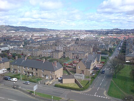
Broomhouse is a district of Edinburgh, Scotland. Although on the lands of Old Saughton, its name is adopted from an estate which lay to the north of the Edinburgh and Glasgow Railway. The earliest recorded versions of the name (c.1600) were variations on Brum(e)hous. It mainly comprises a low-rise council housing estate built between 1947 and 1950. It borders on Parkhead, Sighthill, and Saughton Mains. The arterial route of Calder Road (A71) passes to the south.
Excerpt from the Wikipedia article Broomhouse, Edinburgh (License: CC BY-SA 3.0, Authors, Images).Broomhouse, Edinburgh
Broomhouse Place North, City of Edinburgh Sighthill, Broomhouse and Parkhead
Geographical coordinates (GPS) Address Nearby Places Show on map
Geographical coordinates (GPS)
| Latitude | Longitude |
|---|---|
| N 55.928333333333 ° | E -3.2808472222222 ° |
Address
Broomhouse Place North 20A
EH11 3UF City of Edinburgh, Sighthill, Broomhouse and Parkhead
Scotland, United Kingdom
Open on Google Maps


