Bergrat Müller Pond
Harz (district)Mining in the HarzPonds of Saxony-AnhaltQuedlinburgSelke basin

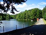
The Bergrat Müller Pond (German: Bergrat-Müller-Teich), named after a former mining director, Müller, in the Harz mountains of central Germany is a storage pond laid out from 1737 to 1738. It has an area of about 1.3 ha and lies in the forested southern part of the borough of Quedlinburg in the county of Harz in Saxony-Anhalt.
Excerpt from the Wikipedia article Bergrat Müller Pond (License: CC BY-SA 3.0, Authors, Images).Bergrat Müller Pond
Alte Heer- und Handelsstraße,
Geographical coordinates (GPS) Address Nearby Places Show on map
Geographical coordinates (GPS)
| Latitude | Longitude |
|---|---|
| N 51.679583333333 ° | E 11.063972222222 ° |
Address
Alte Heer- und Handelsstraße
06485
Saxony-Anhalt, Germany
Open on Google Maps


