place

Fort Henry, Dorset

Bunkers in the United KingdomGrade II listed buildings in DorsetMilitary history of DorsetWorld War II sites in England
Fort Henry Bunker
Fort Henry Bunker

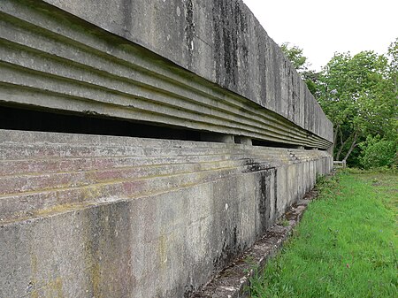
Fort Henry is a Grade II listed World War Two observation bunker overlooking Studland Bay, in Dorset. It was built in 1943 to defend the bay from possible German invasion along with other beach defences such as gun emplacements, Type 25 pill boxes and concrete Dragon’s Teeth anti-tank obstacles (which have also been listed for protection).Located at the top of Redend Point, on a small sandstone promontory, the bunker is 90 feet (27 m) long with walls, floor and ceiling all 3 feet (0.91 m) thick. There is an 80 feet (24 m) wide recessed observation slit. Its name derives from the home base in Ontario of the Canadian Royal Engineers who built it. Today, it is owned by the National Trust and forms part of the Studland Beach Second World War walk.An English Heritage spokesman commented following the bunker's listing on 20 November 2012: Fort Henry provides an impression of the scale and significance of the preparations for D-Day and is associated with the most prominent figures of the Allied forces. Studland Bay is known for its beaches and wildlife but it is great that its role in the Second World War has now been recognised.

Excerpt from the Wikipedia article Fort Henry, Dorset (License: CC BY-SA 3.0, Authors, Images).

Fort Henry, Dorset
Manor Road,

Geographical coordinates (GPS) Address External links Nearby Places
placeShow on map

Wikipedia: Fort Henry, DorsetContinue reading on Wikipedia

Geographical coordinates (GPS)

Latitude Longitude
N 50.64524 ° E -1.94785 °
placeShow on map

Address

Fort Henry

Manor Road
BH19 3AU , Studland
England, United Kingdom
mapOpen on Google Maps

linkWikiData (Q5471318)
linkOpenStreetMap (194785041)

Fort Henry Bunker
Fort Henry Bunker
Share experience

Nearby Places

Ballard Down
Ballard Down

Ballard Down is an area of chalk downland on the Purbeck Hills in the English county of Dorset. The hills meet the English Channel here, and Ballard Down forms a headland, Ballard Point, between Studland Bay to the north and Swanage Bay to the south. The chalk here forms part of a system of chalk downlands in southern England, and once formed a continuous ridge between what is now west Dorset and the present day Isle of Wight. Old Harry Rocks, just offshore from the dip slope of the down, and The Needles on the westernmost tip of the Isle of Wight, are remnants of this ridge. The scarp slope of the down faces south, over Swanage, meeting the sea as Ballard Cliff. The down was an area of calcareous grassland for up to 1000 years until World War II, when there was a sudden rise in the need for arable agricultural land. The down is now owned by the National Trust, and has largely been returned to grassland. The National Trust allows grazing on the down to prevent it becoming a natural beech woodland climax community. The obelisk at Ballard Down commemorates the provision of a new supply of drinking water for Swanage in 1883. Erected in 1892 by George Burt, it was taken down in 1941 as it was a landmark that might have aided enemy aircraft during World War II, but was re-erected in 1952. Ballard Down forms the easternmost part of the Jurassic Coast World Heritage Site.The BBC's adaptation of EM Forster's novel 'Howards End' (2017) used Ballard Down as a location.