Tsim Sha Tsui

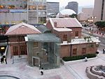
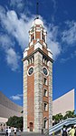
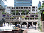
Tsim Sha Tsui, often abbreviated as TST, is an urban area in southern Kowloon, Hong Kong. The area is administratively part of the Yau Tsim Mong District. Tsim Sha Tsui East is a piece of land reclaimed from the Hung Hom Bay now east of Tsim Sha Tsui. The area is bounded north by Austin Road and in the east by Hong Chong Road and Cheong Wan Road. Geographically, Tsim Sha Tsui is a cape on the tip of the Kowloon Peninsula pointing towards Victoria Harbour, opposite Central. Several villages had been established in this location before Kowloon was ceded to the British Empire in 1860. The name Tsim Sha Tsui in Cantonese means sharp sandspit. It was also known as Heung Po Tau (香埗頭), i.e. a port for exporting incense tree. Tsim Sha Tsui is a major tourist hub in Hong Kong, with many high-end shops, bars, pubs and restaurants that cater to tourists. Many of Hong Kong's museums are located in the area.
Excerpt from the Wikipedia article Tsim Sha Tsui (License: CC BY-SA 3.0, Authors, Images).Tsim Sha Tsui
Salisbury Road, Kowloon Tsim Sha Tsui (Yau Tsim Mong District)
Geographical coordinates (GPS) Address Phone number Website Nearby Places Show on map
 Continue reading on Wikipedia
 Geographical coordinates (GPS)
| Latitude | Longitude |
|---|---|
| N 22.293888888889 ° | E 114.17111111111 ° |
Address
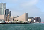
香港文化中心 Hong Kong Cultural Centre
Salisbury Road
Kowloon, Tsim Sha Tsui (Yau Tsim Mong District)
Hong Kong, China
Open on Google Maps
Phone number
Website
lcsd.gov.hk