Lyons Dam

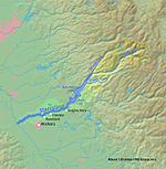
Lyons Dam (National ID # CA00387) is a dam in Tuolumne County, California. The concrete single-arch dam was constructed in 1930 (1930) by the Pacific Gas and Electric Company, with a height of 132 feet (40 m) and a length of 535 feet (163 m) at its crest. It impounds the South Fork Stanislaus River for the municipal water supply of the Twain Harte, California area. Owned and operated by Pacific Gas and Electric Company, the largest private owner of hydroelectric facilities in the United States, it is one of the company's 174 dams. The reservoir it creates, Lyons Reservoir, has a normal water surface of 184 acres (74 ha), and a maximum capacity of 6,400 acre-feet (7,900,000 m3). Recreation includes fishing. The site is surrounded by the Stanislaus National Forest. In 2012, about 625 acres (253 ha) of adjacent land known as the Rushing Meadows parcel was transferred from PG&E's ownership to the National Forest Service, as part of the utility's bankruptcy settlement.
Excerpt from the Wikipedia article Lyons Dam (License: CC BY-SA 3.0, Authors, Images).Lyons Dam
Main Tuolumne Ditch Trail,
Geographical coordinates (GPS) Address Nearby Places Show on map
Geographical coordinates (GPS)
| Latitude | Longitude |
|---|---|
| N 38.09427 ° | E -120.16712 ° |
Address
Main Tuolumne Ditch Trail
Main Tuolumne Ditch Trail
95373
California, United States
Open on Google Maps


