place

Wiggins Hill

Areas of Birmingham, West MidlandsSutton ColdfieldUse British English from May 2022
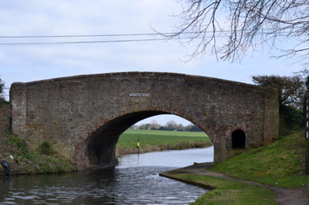
Wiggins Hill bridge
Wiggins Hill bridge

Wiggins Hill (sometimes spelled Wigginshill) is a hamlet situated in the Minworth area of the civil parish of Sutton Coldfield, West Midlands. It lies within the City of Birmingham on its northeastern outer fringe, where it forms part of the Sutton Walmley and Minworth electoral ward and borders the North Warwickshire district. It is about halfway between Minworth and Curdworth, and was first documented in the Domesday Book as one of Turchill de Arden's manors. It was spelt then as 'Winchicelle', which meant 'The hill of Wicga's People'. It also had a seal of antiquity in Magna Carta, and during that time was known as Wincelle. In the fields nearby, Roman coins of the third and fourth centuries have been found, also earthwork features of medieval times. The main buildings in Wiggins Hill date to the 17th century. There is a half-timbered cottage with a large barn and a farmhouse with a Dutch gable. Wiggins Hill was a major meeting place for Quakers, with a meeting house and cottage being built there in 1724 by the group. Construction cost £100, of which £40 was raised by collections in the county. However, by the 19th century, the number of those attending was low resulting in the closure of the meeting house, which eventually fell into dilapidation. Wiggins Hill did consist of a 15th-century timber-framed house named Wincelle (the name of the hamlet in Magna Carta); however, in 1910, it was dismantled and reassembled at its current site overlooking New Hall Valley Country Park, in New Hall Valley on the Wylde Green Road in Walmley, Sutton Coldfield. The nearby Birmingham and Fazeley Canal was built in 1789 and brought passing trade.

Excerpt from the Wikipedia article Wiggins Hill (License: CC BY-SA 3.0, Authors, Images).

Wiggins Hill
Wiggins Hill Road, Birmingham

Geographical coordinates (GPS) Address Nearby Places
placeShow on map

Wikipedia: Wiggins HillContinue reading on Wikipedia

Geographical coordinates (GPS)

Latitude Longitude
N 52.535 ° E -1.755 °
placeShow on map

Address

Wiggins Hill Road

Wiggins Hill Road
B76 9QE Birmingham
England, United Kingdom
mapOpen on Google Maps

Wiggins Hill bridge
Wiggins Hill bridge
Share experience

Nearby Places

Wishaw, Warwickshire

Wishaw is a village and civil parish in the north-west of Warwickshire, England. The population of the civil parish at the 2011 census was 125. It is located within the district of North Warwickshire and is the home of The Belfry golf resort, which has hosted the Ryder Cup on four occasions. The village is also home to some notable buildings. The site of The Belfry was once the location of Moxhull Park, a stately home that belonged to the Ryland family (previously the Halket family) until it burnt down in the early twentieth century. The manor house was rebuilt one mile away to its present location on Holly Lane as Moxhull Hall. Wishaw is also the location of a church dedicated to the local Saint Chad. The church is popular with marriages and regular Sunday services, despite a very small local population. Wishaw is also the home of Wishaw Country Sports, a diverse venue that offers a variety of activities such as shooting, blindfold driving and tractor driving. It also features a converted farm building which is now used as a luxury event venue, offering birthdays, weddings and other functions upon request. Wishaw is located about one mile north of the village of Curdworth and about three miles east of the town of Sutton Coldfield, in the West Midlands. In 2003, residents claimed that a mobile phone mast at the centre of the village was the cause of a local cancer cluster. The mast was felled by unknown vandals in November 2003 and subsequent pressure against plans to replace it led operator T-Mobile to abandon the site.

Peddimore Hall
Peddimore Hall

Peddimore Hall is a manor house in the Walmley area of Sutton Coldfield in Birmingham, West Midlands, England. It is a Scheduled Ancient Monument and a Grade II listed building. It is now in use as a private residence. Peddimore was first mentioned in 1281 when it was conveyed by Thomas Arden of Ratley to Hugh de Vienne and subsequently to Thomas and Rose de Arden of Hanwell in 1286. In 1288, the owners of Peddimore Hall were allowed by the Earl of Warwick, William de Beauchamp to fish in Ebrook (now Plants Brook) on his land, allow his pigs to roam in the woods and was allowed to remove timber for building reparations.A building on site is first mentioned in 1361 when John de Arden was granted a licence for a private chapel.Peddimore Hall is encircled by a double moat, which forms a rectangular site. A double moat was often used as a status symbol during the time, however, it was also practical in preventing access from thieves, enclosing livestock and also provided water for fires or animals. The double moat dates to the 13th century and a manor has been located on the rectangular site since 1281. The current brick structure was built in 1659 on the site of an earlier homestead, the structure of which may partly be incorporated into it. It was built by William Wilson and first occupied by William Wood, a prominent Royalist and Warden of the Sutton Corporation in 1662 and 1676. There are farm buildings within the grounds, some of which are timber-framed. The building is built of red brick with red sandstone angle-dressings and moulded plinth. It is two storeys tall. A drawbridge crosses the moat at the entrance. The old timber-framed barn on the farm dates from 1385 and is believed to have not been altered since that date.When World War II began, the government commissioned a photographic record of the house and grounds for if it were destroyed by bombing. Although a large bomb did explode in nearby Walmley Ash Lane, the house was not damaged in the war.Archaeological work has been conducted in 1977 and 1980. The first work in 1977 was a ground survey and the 1980 investigation consisted of excavations on site. An archaeological evaluation was carried out by the Birmingham University Field Archaeology Unit in 1998.