place

Church of Prophet Elijah (Thessaloniki)

14th-century Eastern Orthodox church buildings14th-century churches in Greece14th-century establishments in the Byzantine EmpireByzantine church buildings in ThessalonikiFormer mosques in Greece
Mosques converted from churches in Ottoman GreeceWorld Heritage Sites in Greece
Church of Prophet Elias 01

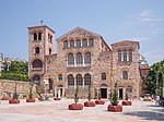
The Church of Prophet Elijah (Greek: Ναός Προφήτη Ηλία, Naós Profíti Ilía) is a 14th-century church in Thessaloniki, Greece, and a UNESCO World Heritage Site.The church is located in the upper quarter of the old city, and dates to the Palaiologan period, but its original dedication is unknown. In Ottoman times, it was known as the Saraylı Mosque (Palace Mosque or Court Mosque), and through a misinterpretation of this name came about its modern dedication to the Prophet Elijah. It has been traditionally identified as the katholikon of the Nea Moni monastery, built ca. 1360–1370 on the site of a former palace destroyed in 1342 by the Zealot uprising. Modern research, however, has cast doubt on this, since the Nea Moni continued to operate well into the Ottoman period, while the church of Prophet Elijah was converted into a mosque by Badrah Mustafa Pasha immediately after the city's capture in 1430. On the basis of its internal decoration, it has been suggested that the church was the katholikon of the important Akapniou Monastery.Its architectural style, a variant of cross-in-square church known as the "Athonite type", is unique in the city, and was always reserved for katholika of monasteries. The careful masonry, of alternating courses of bricks and white ashlar, is also unusual for Thessaloniki and its region; it is copied from Constantinopolitan architecture. Several of its architectural features have also been interpreted as set to create an ambient atmosphere directly connected with the type of worship, through the way natural light is distributed. Fragments of the church's original decoration survive in the form of wall paintings, fine examples of late Palaiologan art, which influenced later paintings in Serbia.

Excerpt from the Wikipedia article Church of Prophet Elijah (Thessaloniki) (License: CC BY-SA 3.0, Authors, Images).

Church of Prophet Elijah (Thessaloniki)
Προφήτου Ηλία, Thessaloniki Municipal Unit Kamara (3rd District of Thessaloniki)

Geographical coordinates (GPS) Address Nearby Places
placeShow on map

Wikipedia: Church of Prophet Elijah (Thessaloniki)Continue reading on Wikipedia

Geographical coordinates (GPS)

Latitude Longitude
N 40.640833333333 ° E 22.948333333333 °
placeShow on map

Address

Προφήτου Ηλία 8
546 31 Thessaloniki Municipal Unit, Kamara (3rd District of Thessaloniki)
Macedonia and Thrace, Greece
mapOpen on Google Maps

Church of Prophet Elias 01
Share experience

Nearby Places

National Map Library

The National Map Library (Greek: Εθνική Χαρτοθήκη), properly the National Centre for Maps and Cartographic Heritage - National Map Library, is located in Thessaloniki, Central Macedonia, Greece. It was established in 1997 (Law 2466/1997) for the purpose of preserving, archiving, conserving, promoting, and displaying maps, studying the educational, cultural, and social role of maps, collaborating at a scientific and technical level with national and international organizations, organizing permanent and mobile exhibitions accompanied by catalogues, utilising public and private map collections, and organising seminars and conferences. Since February 1999 the National Map Library has been housed in a two-storey listed building in the Upper Town (Ano Poli). On the ground floor are the scientific and administrative departments and on the first floor there is a permanent exhibition space which hosts frequent cartographic exhibitions. There is an archive of 1,000 maps, which are being electronically documented and archived with the help of a special database. Between 1 and 12 November 1999, there was an exhibition of six 19th-century cartoon maps of Europe, five children's maps which had been entered for the international cartographic competition in 1999, and some rare maps drawn by Sotiris Zissis, a self-taught Thessalonian cartographer. Other exhibitions organised by the National Map Library include History in Maps at the Residency, Maps of Ports of Greek Cities of the Twentieth Century in the National Research Institute, and Greek Cartography in Thessaloniki in the Twentieth Century. An educational programme titled The National Map Library Meets Teachers and Children has been drawn up and is addressed to schools in Macedonia and Thrace.

Upper Town (Thessaloniki)

Thessaloniki's Upper Town called Ano Poli (Greek: Άνω Πόλη, [ˈano ˈpoli]) is the old town of Thessaloniki and is located around the city's acropolis north of the city center. The neighborhood is known for its well preserved Byzantine and Ottoman era structures and urban design and as a center for Thessaloniki's poets, intellectuals, and bohemians. Ano Poli is one of the most traditional areas in Thessaloniki. The area preserves much of the Byzantine and Ottoman era city design which was largely destroyed elsewhere in the city in the Great Fire of 1917. It is known for its small stone-paved streets, old squares, and houses in traditional Greek and Ottoman architecture. Ano Poli is the highest part of the city and is dominated by the city's acropolis, a Byzantine and Ottoman era fort known as the Eptapyrgio. What remains of the old city walls still surround Ano Poli and many Ottoman and Byzantine structures such as the church of Profitis Elias, the Church of Saint Nicholas Orphanos, the Taxiarches church, the Byzantine bath, the Church of Saint Catherine, the Vlatades Monastery, the Atatürk Museum, and the Alaca Imaret Mosque still stand in the neighborhood. Other landmarks include the buildings of Villa Moskof and Villa Varvara. During the Ottoman period Ano Poli was the main district for the Turks (Muslims) of the city while Greeks, western Europeans, and Jews lived below around the port. On clear days Mount Olympus, about 80 km (50 mi) away across the gulf, can also be seen towering the horizon.