place

Port Noarlunga, South Australia

Gulf St VincentSuburbs of AdelaideUnderwater diving sites in AustraliaUse Australian English from August 2019Whaling stations in Australia
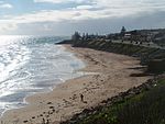
Port Noarlunga South Australia (15324590967)

Port Noarlunga is a suburb in the City of Onkaparinga, South Australia. It is a small sea-side suburb, population 2,918, about 30 kilometres (19 miles) to the south of the Adelaide city centre and was originally created as a sea port. This area is now popular as a holiday destination or for permanent residents wishing to commute to Adelaide or work locally. There is a jetty that connects to a 1.6 kilometres (0.99 miles) long natural reef that is exposed at low tide. The beach is large and very long and has reasonable surfing in the South Port area whose name is taken from its location - "South of the Port".It is known as Tainbarang or Tainbarilla by the traditional owners, the Kaurna people, and is of significance as being the site of a freshwater spring said to be created by the tears of Tjilbruke, the creator being. A reserve known as the Tutu Wirra Reserve, on Witton Bluff, is the location of the stone cairn commemorating the second spring created by Tjilbruke on his journey down the coast.The suburb is bounded to the south by the Onkaparinga River, including a tidal estuary. It is bounded to the west by the coastline with Gulf St Vincent, by Christies Beach to the north and by Noarlunga Centre and Noarlunga Downs to the east.

Excerpt from the Wikipedia article Port Noarlunga, South Australia (License: CC BY-SA 3.0, Authors, Images).

Port Noarlunga, South Australia
Gawler Street, Adelaide Port Noarlunga

Geographical coordinates (GPS) Address Nearby Places
placeShow on map

Wikipedia: Port Noarlunga, South AustraliaContinue reading on Wikipedia

Geographical coordinates (GPS)

Latitude Longitude
N -35.149003 ° E 138.4752 °
placeShow on map

Address

Stop 71 Gawler Street - South East side

Gawler Street
5167 Adelaide, Port Noarlunga
South Australia, Australia
mapOpen on Google Maps

Port Noarlunga South Australia (15324590967)
Share experience

Nearby Places

Port Noarlunga South, South Australia

Port Noarlunga South is a suburb in the Australian state of South Australia located in the Adelaide metropolitan area on the coastline of Gulf St Vincent about 30 kilometres (19 miles) south of the state capital of Adelaide.Port Noarlunga South started as a private sub-division in 1923 with portions gazetted with the names Paringa and Port Onkaparinga. A portion of land was added to the suburb in 1960 from an area known as Onkaparinga and was subsequently removed in 1995 to create the suburb of Seaford Meadows. In April 2001, the South Port Surf Life Saving Club submitted a proposal to rename parts of both the suburbs of Port Noarlunga and Port Noarlunga South as South Port. However, this proposal was withdrawn in August 2001 following discussions with the City of Onkaparinga regarding "locational identification issues " and replace with a request to "investigate the naming of South Port Beach."Port Noarlunga South is bounded by the centre of the channel of the Onkaparinga River to the north, the coastline with Gulf St Vincent to the west, Aldam Road to the South and to the east by Commercial Road in part in the south, the centre of the Onkaparinga River in part and a line connecting both parts. Land use within the suburb consists of residential on its west side and 'open space' for land located within the Onkaparinga River Recreation Park on its east side.Port Noarlunga South is located within the federal Division of Kingston, the state electoral district of Kaurna and the local government area of the City of Onkaparinga.

Hickinbotham Oval
Hickinbotham Oval

Hickinbotham Oval (currently known as Flinders University Stadium due to naming rights, and originally Noarlunga Oval) is an Australian rules football stadium in Noarlunga Downs, an outer-southern suburb of Adelaide. It has been the home of South Australian National Football League (SANFL) club South Adelaide Football Club (also known as "The Panthers") since 1995. In 2018 the ground was re-named Flinders University Stadium, as part of a five-year sponsorship deal with Flinders University.After 111 years (in two stints, 1882-1903 and 1904-1994) of playing their home games at the Adelaide Oval, (which is located on the northern side of the Adelaide city centre and the Torrens River), the club decided to move to the southern suburb of Noarlunga in the early 1990s. The club had played two games at the Bice Oval in Christies Beach (approximately 1.5km from Hickinbotham) in 1992 and 1993 in order to gauge support in the area for the club. Approximately 8,000 fans crammed into the oval in 1993 to see the Panthers take on the Glenelg Tigers. That level of community support was one of the determining factors in South Adelaide's decision to permanently move to Noarlunga, becoming a community based club for the first time in its then 119-year history. The Panthers clubrooms and administration offices, which had previously been located on South Road at St Marys (directly opposite the then Mitsubishi Motors factory at Tonsley Park), were also relocated to the Noarlunga Oval.