A Illa de Arousa

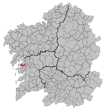
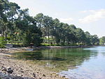
A Illa de Arousa is the only island municipality in Galicia, Spain in the province of Pontevedra. It is located in the heart of the Ria de Arousa. According to 2021 INE the island's population was 4,951 inhabitants. The population is divided into several neighborhoods, and places of interest are the lighthouse's environment, the island of Areoso (close to the Illa de Arousa) and Carreirón Natural Park, which is listed as a special protection zone for heron birds populations among other birds that inhabit the island. The Holy viewpoint is the highest point on the island. "San Xulián da Illa de Arousa" is the only parish in this island. Some of its beaches are the following ones: A Area da Secada, A Lavanqueira, O Vao, Camaxe, Carreirón, Espiñeiro and O Cabodeiro. A Illa de Arousa has five ports. Xufre is the most important and the other important docks include O Campo, Chazo and Cabodeiro.
Excerpt from the Wikipedia article A Illa de Arousa (License: CC BY-SA 3.0, Authors, Images).A Illa de Arousa
Avenida da Ponte, A Illa de Arousa
Geographical coordinates (GPS) Address Nearby Places Show on map
Geographical coordinates (GPS)
| Latitude | Longitude |
|---|---|
| N 42.554444444444 ° | E -8.8638888888889 ° |
Address
Avenida da Ponte
Avenida da Ponte
36626 A Illa de Arousa
Galicia, Spain
Open on Google Maps


