place

Aach, Rhineland-Palatinate

Holocaust locations in GermanyMunicipalities in Rhineland-PalatinatePages that use PhonosTrier-Saarburg
Hohensonne Kirche1
Hohensonne Kirche1

Aach (German: [aːx] ) is a municipality in the German state of Rhineland-Palatinate. It is part of Trier-Land, a Verbandsgemeinde.

Excerpt from the Wikipedia article Aach, Rhineland-Palatinate (License: CC BY-SA 3.0, Authors, Images).

Aach, Rhineland-Palatinate
Rotmauer, Trier-Land

Geographical coordinates (GPS) Address Nearby Places
placeShow on map

Wikipedia: Aach, Rhineland-PalatinateContinue reading on Wikipedia

Geographical coordinates (GPS)

Latitude Longitude
N 49.791111111111 ° E 6.59 °
placeShow on map

Address

Rotmauer 2
54298 Trier-Land
Rhineland-Palatinate, Germany
mapOpen on Google Maps

Hohensonne Kirche1
Hohensonne Kirche1
Share experience

Nearby Places

Trier (region)
Trier (region)

Trier was one of the three Regierungsbezirke of Rhineland-Palatinate, Germany, located in the west of the state. The region was created in 1815 as part of the Prussian Rhineland. Until 1920 the bulk of what then became the Territory of Saar Basin was part of the Trier Region. Only the east of the Saar Territory, today's Saar-Palatinate district, formerly the western fringes of the then Bavarian Rhenish Palatinate, was previously no part of the Trier Region. In April 1937 the St. Wendel-Baumholder district, formed in 1920 from those parts of the St. Wendel district that had not been seceded to the Saar Territory, was dissected from the Trier Region and merged in the new Birkenfeld district within the Koblenz Region. After the Second World War the French military government several times extended the Saar area before forming the Saar Protectorate, also including additional 109 municipalities belonging until July 1946 to the Trier Region and some to the Koblenz Region. Koblenz Region's former areas make up part of today's St. Wendel district in the Saarland. In December 1946, when a new customs boundary dissected the Saar Protectorate (later becoming the Saarland) from the area under the Allied Control Council over Allied-occupied Germany, the Trier Region with its then remaining territory had become one of the then five regions forming the new state of Rhineland-Palatinate, founded in August 1946. Later, the French occupation government again redeployed some municipalities – some returned to Allied-occupied Germany, some newly annexed to the protectorate – between the Saar area and the new state of Rhineland-Palatinate in 1947 and 1949, before the border was finally fixed. Since 2000, the employees and assets of the Bezirksregierungen (i.e. regional administrations) form the Aufsichts- und Dienstleistungsdirektion Trier (ADD; Supervisory and Service Directorate Trier) and the Struktur- und Genehmigungsdirektionen (SGD; Structural and Approval Directorates) Nord in Koblenz and Süd in Neustadt (Weinstraße). These administrations execute their authority over the whole state, i. e. the ADD Trier oversees all schools.

Sarre (department)
Sarre (department)

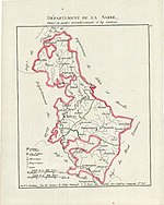
Sarre was a department in the First French Republic and First French Empire. Its territory is now part of Germany and Belgium. Named after the river Saar (French: Sarre), it was created in 1798 in the aftermath of the Treaty of Campo Formio of 18 October 1797 which ceded the left bank of the Rhine to France. Despite its name it covered a much larger area than the historical area known as the Saarland. Prior to the French occupation of the area from 1793 onward, its territory had been divided between the Electorate of Trier, Nassau-Saarbrücken and the Electorate of the Palatinate (the Duchy of Zweibrücken and the County of Veldenz). Its territory is now part of the German states Rhineland-Palatinate and Saarland as well as a tiny adjacent section of the Belgian province of Liège. Its capital was Trier. The department was subdivided into the following arrondissements and cantons (situation in 1812): Trier (French: Trèves), cantons Bernkastel, Büdlich, Konz, Pfalzel, Saarburg, Schweich, Trier and Wittlich. Birkenfeld, cantons: Baumholder, Birkenfeld, Grumbach, Hermeskeil, Herrstein, Kusel, Meisenheim, Rhaunen and Wadern. Prüm, cantons: Blankenheim, Daun, Gerolstein, Kyllburg, Lissendorf, Manderscheid, Prüm, Reifferscheid and Schönberg. Saarbrücken (French: Sarrebrück), cantons: Blieskastel, Lebach, Merzig, Ottweiler, Saarbrücken, Sankt Wendel and Waldmohr.Its population in 1812 was 277,596, and its area was 493,513 hectares (1,219,500 acres).After Napoleon was defeated in 1814, most of the department became part of Prussia, with smaller parts assigned to Duchy of Oldenburg (Birkenfeld) and Bavaria. The cantons of Sankt Wendel and Baumholder were given to Saxe-Coburg-Saalfeld as the Principality of Lichtenberg, which was sold to Prussia in 1834. The canton of Meisenheim was given to Hesse-Homburg, which was annexed to Prussia in 1866. France retained Saarbrücken but, after Waterloo, it was punished and it lost the town together with Saarlouis from nearby Moselle. The former Schönberg canton would later be included in the Eupen-Sankt Vith-Malmedy plebiscite area following World War I.