place

Saint-Maurice, Switzerland

Cities in SwitzerlandCultural property of national significance in ValaisMunicipalities of ValaisPopulated places on the RhônePopulated riverside places in Switzerland
Saint Maurice (VS) juillet 2022

Saint-Maurice is a city in the Swiss canton of Valais and the capital of the district of Saint-Maurice. On 1 January 2013, the former municipality of Mex merged into the municipality of Saint-Maurice.Saint-Maurice is the site of the Ancient Roman outpost of Agaunum and the 6th-century Abbey of Saint-Maurice d'Agaune. The city is located at the entrance of a pass leading to the upper part of the Rhône valley. As such, it has a strategic importance, and defence work were built from the 15th century to control this access. The Fortress Saint-Maurice was constructed in the surrounding mountainsides from 1880 through 1995.

Excerpt from the Wikipedia article Saint-Maurice, Switzerland (License: CC BY-SA 3.0, Authors, Images).

Saint-Maurice, Switzerland
Sous-le-Scex,

Geographical coordinates (GPS) Address Nearby Places
placeShow on map

Wikipedia: Saint-Maurice, SwitzerlandContinue reading on Wikipedia

Geographical coordinates (GPS)

Latitude Longitude
N 46.216666666667 ° E 7 °
placeShow on map

Address

Sous-le-Scex 5
1890 (Saint-Maurice)
Wallis, Switzerland
mapOpen on Google Maps

Saint Maurice (VS) juillet 2022
Share experience

Nearby Places

Grotte aux Fées (Switzerland)

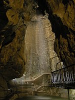
The Grotte aux Fées ("Cave of the Fairies") in the cliffs above Saint-Maurice, Switzerland is a natural limestone solution show cave, featuring a 77-metre (253 ft) high underground waterfall, claimed as the world's highest waterfall in a show cave. The cave was the first show cave in Switzerland. The cave was known until the mid 19th century as the Trou aux Fayes or "Sheep Hole," as it was used as a sheepfold. The cave was known from Roman times, but was first publicized in 1863 as a tourist attraction, with the present name being used from 1865.The cave was explored in 1831 when a party mapped 600 metres (2,000 ft) of passages. From 1863 Professor Chanoine Gard of the Abbey College of Saint-Maurice cleared passageways and conducted tours on behalf of an orphanage that he had founded. From 1865 the cave was operated by the Sisters of Saint-Maurice, who coined the present name. In 1925 additional exploration extended the cave network from the top of the waterfall. The network includes the 504 metres (1,654 ft) tourist gallery, the 1,200-metre (3,900 ft) Galerie des Morts and the 2,184-metre (7,165 ft) Fairies' Cave section, with an elevation difference of 122 metres (400 ft). A 2010 exploration linked the Grotte aux Fées to the nearby Grotte de Saint-Martin No.1, totaling 3,630 metres (11,910 ft) in length and 249 metres (817 ft) in elevation.The guided tour follows a 500-metre (1,600 ft) trail, ending at the waterfall. The waterfall is fed by water from the nearby Dents du Midi peaks.The cave was connected to Fort du Scex, which occupies the same cliff, between 1935 and 1936. The cave in turn was connected to Fort de Cindey between 1941 and 1946, forming part of the fortifications of Fortress Saint-Maurice and providing an underground connection between the two fortifications. The cave and both forts may be visited during summer months.

Fortress Saint-Maurice

Fortress Saint-Maurice is one of the three main fortification complexes comprising the Swiss National Redoubt. The westernmost of the three, Fortress Saint-Maurice complements Fortress Saint Gotthard and Fortress Sargans to secure the central alpine region of Switzerland against an invading force. The National Redoubt was first conceived in the 1880s as an easily defensible area to secure the survival of the Swiss Confederation. In the late 1930s and 1940s when neutral Switzerland was threatened with invasion from Germany, the National Redoubt and its components were modernized and expanded on a massive scale. The fortification system was maintained and upgraded during the Cold War. With the collapse of the Soviet Union, the possibility of a Warsaw Pact invasion disappeared, and by 1995 many positions were abandoned by the military. Fortress Saint-Maurice encompasses the area around Saint-Maurice in the western, French-speaking portion of Switzerland. The Rhône river leaves the central Alpine region at Saint-Maurice through a narrow defile, between 4000m mountains to the south and 3000m mountains to the north. The only comparatively easy access to the upper Rhône valley, and thus to the western National Redoubt, is through Saint-Maurice. Fortress Saint-Maurice is a series of fortifications set into the mountains on either side of the valley, dominating the region as far as Lac Léman with their artillery. The principal fortification is the enormous Fort de Dailly, supported by forts Savartan, Scex and Cindey, as well as lesser positions. The extent of the area designated as Fortress Saint-Maurice is not clearly defined, but according to the Association Fort de Litroz, the Saint-Maurice sector comprises the Rhône narrows from just north of Saint-Maurice to Martigny, excluding Chillon and Champillon, as well as the fortifications of the lateral valleys.