place

Temple Balsall

Conservation areas in EnglandKnights TemplarPreceptories of the Knights Hospitaller in EnglandSolihullVillages in the West Midlands (county)
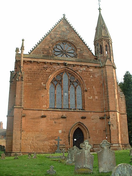
Temple Balsall Church

Temple Balsall (grid reference SP207760) is a small hamlet within the Metropolitan Borough of Solihull in the English West Midlands, situated between the large villages of Knowle (where population details as taken at the 2011 census can be found) and Balsall Common. It was formerly in Warwickshire and is on a notoriously bad series of bends on the B4101 Kenilworth Road. It is one of the oldest and most interesting sites in the borough. It is named after, and dates from the time of, the Knights Templar. They farmed about 650 acres (2.6 km2) of the estate in the 12th century, and established Balsall Preceptory where a number of brothers lived and ran the estate. After the Order was suppressed, the estate was given to the Knights Hospitaller of St John. They lost it when Henry VIII dissolved the monasteries and Queen Elizabeth I gave the estate to Robert Dudley. The 13th-century church and Old Hall, and 17th-century almshouses survive. Robert Dudley's granddaughter, Lady Katharine Leveson of Trentham Hall, Staffordshire, inherited the estate. On her death in 1674, Lady Leveson left endowments for almshouses, the Lady Katharine Leveson primary school and the local church. There are only a handful of residences in the hamlet.

Excerpt from the Wikipedia article Temple Balsall (License: CC BY-SA 3.0, Authors, Images).

Temple Balsall
Fen End Road West,

Geographical coordinates (GPS) Address Nearby Places
placeShow on map

Wikipedia: Temple BalsallContinue reading on Wikipedia

Geographical coordinates (GPS)

Latitude Longitude
N 52.382 ° E -1.697 °
placeShow on map

Address

Fen End Road West
B93 0AN , Balsall
England, United Kingdom
mapOpen on Google Maps

Temple Balsall Church
Share experience

Nearby Places

Barston
Barston

Barston is a village and civil parish in Metropolitan Borough of Solihull in the West Midlands of England. It is approximately 4.5 miles (7 km) east of Solihull and is located inside a large meander of the River Blythe, at the western edge of the Meriden Gap, and midway between the far larger villages of Balsall Common and Hampton-in-Arden. The nearest large city is Birmingham, 11 miles (18 km) away to the west. According to the 2001 UK Census, the parish had a population of 499, increasing to 533 at the 2011 Census.Barston is an affluent village with many historic buildings, some of which are timber-framed. The Church of St. Swithin is a Church of England church which dates from 1721, and is built on the site of an earlier church. The village also possesses two pubs, The Bulls Head Archived 14 December 2018 at the Wayback Machine and The Malt Shovel, and about 50 residential properties. The Barston Memorial Institute, opposite the Bulls Head, hosts many village activities with a Friday night youth club and regular Art Classes as well as the Barston WI and U3A meetings. There is no bus service or any other form of public transport in the village, although an abandoned bus stop still exists at the end of the central road of Barston, Oak Lane, which is left over from an old-school service from the 1970s and 1980s. Next to the bus stop is an old-fashioned red phone box. The footballer Robbie Keane owned a house in Barston from 1999 to 2000, whilst playing for Coventry City F.C.