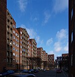
Dronningens Tværgade
Streets in Copenhagen

Dronningens Tværgade (lit. "The Queen's Cross Street") is a street in central Copenhagen, Denmark, which runs from Bredgade to Rosenborg Castle Garden. The street originally formed a link between the King's Garden (Rosenborg Castle Gardens) and the Queen's Garden. With the Odd Fellows Mansion on Bredgade and the central pavilions of the east fringe of the castle garden located at each their end, the street has axial qualities. These are accentuated by the Dronningegården Estate, a Functionalist housing complex from the 1940s, which forms an urban space around the intersection with Adelgade.
Excerpt from the Wikipedia article Dronningens Tværgade (License: CC BY-SA 3.0, Authors, Images).Dronningens Tværgade
Dronningens Tværgade, Copenhagen Christianshavn
Geographical coordinates (GPS) Address Nearby Places Show on map
Geographical coordinates (GPS)
| Latitude | Longitude |
|---|---|
| N 55.684 ° | E 12.5859 ° |
Address
Dronningens Tværgade 30
1302 Copenhagen, Christianshavn
Capital Region of Denmark, Denmark
Open on Google Maps


