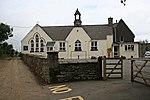
St Wenn (Cornish: Sen Gwenna) is a civil parish and village in Cornwall, England, United Kingdom. The village is situated six miles (10 km) west of Bodmin and nine miles (14.5 km) east of Newquay. The parish population at the 2011 census was 369.Other settlements in the parish include Rosenannon, Demelza, Tregonetha (Cornish: Tregenhetho), and Tregurtha Barton, once the home of Michael Tregury, Archbishop of Dublin who died in 1471. The last heir-male of the elder branch of this family died in the reign of Henry V. The Borlase family, ancestors of William Borlase, were residents of three farms in this parish.
Later William Hals, who wrote the Parochial History of Cornwall, lived here in the latter part of his life: Hals, who owned the rectorial tithes of St Wenn, died here.
There is a Cornish cross at Cross and Hand, a place in the valley next to Castle-an-Dinas and in the extreme south of the parish. This cross (locally known as Crossy Ann) marks the boundary of the parishes of St Wenn, St Columb Major and Roche.


