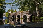
Brushford, Somerset

Brushford is a village and civil parish 2 miles (3.2 km) south of Dulverton and 12 miles (19 km) north of Tiverton in Devon, in the Somerset West and Taunton district of Somerset, England. According to the 2001 census it had a population of 535 in 243 households, reducing to 519 at the 2011 Census. It covers an area of 1,149 hectares (11 km2) of which 3 hectares (0.030 km2) is within the Exmoor National Park. The River Exe which forms the boundary of the parish and the border between Somerset and Devon is crossed by the 18th-century Exe Bridge. The River Barle is crossed by the New Bridge dating from 1870, which led to Pixton Park, and the Weir Bridge which dates from the mid 19th century. West Somerset Polo Club used to play in fields below the village alongside the River Barle. The fields in the area are now mainly grazed by stock. The village consists of a local garage, some housing areas, a playground with a basketball court, a village hall and a church. Its population increased at four times the rate of the UK percentage growth rate, over the years 1994 to 2004 and a need for more affordable housing was identified in 2006.
Excerpt from the Wikipedia article Brushford, Somerset (License: CC BY-SA 3.0, Authors, Images).Brushford, Somerset
Geographical coordinates (GPS) Address Nearby Places Show on map
Geographical coordinates (GPS)
| Latitude | Longitude |
|---|---|
| N 51.0188 ° | E -3.534 ° |
Address
TA22 9AW
England, United Kingdom
Open on Google Maps


