place

Aurach (Regnitz, Oberfranken)

Bavaria river stubsRivers of BavariaRivers of GermanyTributaries of the Regnitz
Aurach bei Stegaurach

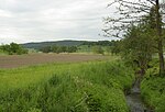
There exists also another river named Aurach that is a tributary of the Regnitz, see Aurach (Regnitz, Mittelfranken). For other uses, see Aurach (disambiguation).Aurach (German pronunciation: [ˈaʊ̯ʁax] (listen)) is a river of Bavaria, Germany. It is a left tributary of the Regnitz in Upper Franconia. The Aurach has its source in the Steigerwald Nature Park west of the village of Oberaurach, between Euerberg and Beerberg. The Aurach first flows in eastern and then in south-eastern direction, through, among others, the districts Priesendorf and Walsdorf of Oberaurach. Its mouth into the Regnitz is downstream from Stegaurach, just north of Pettstadt and somewhat south of Bamberg. The river runs in the north parallel to the Rauhe Ebrach, which flows into the Regnitz just one kilometer southwards of the Aurach, and in the south parallel to the Main, which flows in the opposite direction.

Excerpt from the Wikipedia article Aurach (Regnitz, Oberfranken) (License: CC BY-SA 3.0, Authors, Images).

Aurach (Regnitz, Oberfranken)
BA 29,

Geographical coordinates (GPS) Address Nearby Places
placeShow on map

Wikipedia: Aurach (Regnitz, Oberfranken)Continue reading on Wikipedia

Geographical coordinates (GPS)

Latitude Longitude
N 49.845 ° E 10.935 °
placeShow on map

Address

BA 29
96175
Bavaria, Germany
mapOpen on Google Maps

Aurach bei Stegaurach
Share experience

Nearby Places

Bamberg
Bamberg

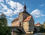
Bamberg (, US also , German: [ˈbambɛʁk] (listen)) is a town in Upper Franconia, Germany, on the river Regnitz close to its confluence with the river Main. The town dates back to the 9th century, when its name was derived from the nearby Babenberch castle. Cited as one of Germany's most beautiful towns, its old town has been a UNESCO World Heritage Site since 1993, with Bamberg being home to Europe's largest intact old city wall. From the 10th century onwards, Bamberg became a key link with the Slav peoples, notably those of Poland and Pomerania. It experienced a period of great prosperity from the 12th century onwards, during which time it was briefly the centre of the Holy Roman Empire. Emperor Henry II was also buried in the old town, alongside his wife Kunigunde. The town's architecture from this period strongly influenced that in Northern Germany and Hungary. From the middle of the 13th century onwards, the bishops were princes of the Empire and ruled Bamberg, overseeing the construction of monumental buildings. This growth was complemented by the obtaining of large portions of the estates of the Counts of Meran in 1248 and 1260 by the see, partly through purchase and partly through the appropriation of extinguished fiefs. Bamberg lost its independence in 1802, following the secularization of church lands, becoming part of Bavaria in 1803. The town was first connected to the German rail system in 1844, which has been an important part of its infrastructure ever since. After a communist uprising took control over Bavaria in the years following World War I, the state government fled to Bamberg and stayed there for almost two years before the Bavarian capital of Munich was retaken by Freikorps units (see Bavarian Soviet Republic). The first republican constitution of Bavaria was passed in Bamberg, becoming known as the Bamberger Verfassung (Bamberg Constitution). Following the Second World War, Bamberg was an important base for the Bavarian, German, and then American military stationed at Warner Barracks, only closing in 2014.