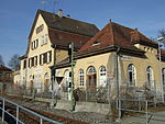
Hirschau (Tübingen)
Boroughs of TübingenVillages in Baden-Württemberg

Hirschau is a village in Tübingen district in Baden-Württemberg, Germany. Since 1971, it is an outer district of the city of Tübingen. Hirschau has a population of 3297 (2020) on an area of 6.17 km2. It is the westernmost district of Tübingen. Hirschau lies to the north of the Neckar river, about 3 km to the east of Wurmlingen, which is a part of Rottenburg am Neckar, and about 6 km to the east of the town centre of Rottenburg am Neckar as well as to the west of the city centre of Tübingen. The highest point is the Spitzberg at 475 m above mean sea level. Unlike most of Tübingen, Hirschau is, like neighbouring Rottenburg, mostly Roman Catholic.
Excerpt from the Wikipedia article Hirschau (Tübingen) (License: CC BY-SA 3.0, Authors, Images).Hirschau (Tübingen)
Kirchplatz,
Geographical coordinates (GPS) Address Website Nearby Places Show on map
Geographical coordinates (GPS)
| Latitude | Longitude |
|---|---|
| N 48.501388888889 ° | E 8.9944444444444 ° |
Address
St. Aegidius
Kirchplatz 4
72070 (Hirschau)
Baden-Württemberg, Germany
Open on Google Maps


