place

Warwick Rural District

Districts of England abolished by the Local Government Act 1972Districts of England created by the Local Government Act 1894History of WarwickshireRural districts of EnglandUse British English from August 2012
Warwickshire geography stubs

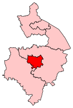
Warwick Rural District was a rural district of Warwickshire, England. It was created in 1894, and covered an area around, but not including, Warwick. It expanded in 1932 with the abolition of Foleshill Rural District and Solihull Rural District. The district was abolished in 1974 under the Local Government Act 1972, merging with Warwick, Leamington Spa, and Kenilworth to form the modern non-metropolitan district of Warwick.

Excerpt from the Wikipedia article Warwick Rural District (License: CC BY-SA 3.0, Authors).

Warwick Rural District
Woodloes Lane,

Geographical coordinates (GPS) Address Nearby Places
placeShow on map

Wikipedia: Warwick Rural DistrictContinue reading on Wikipedia

Geographical coordinates (GPS)

Latitude Longitude
N 52.3 ° E -1.59 °
placeShow on map

Address

Woodloes Lane

Woodloes Lane
CV35 7RE , Leek Wootton and Guy's Cliffe
England, United Kingdom
mapOpen on Google Maps

Share experience

Nearby Places

Priory Park, Warwick

Priory Park is an urban park located in the centre of Warwick, England. Originally the land was the grounds of a 12th-century priory dedicated to St Sepulchre and built in 1124 but this was closed down by King Henry VIII during the dissolution of the Monasteries. It was then destroyed and a residential home was built in 1566 by a man named Thomas Fisher known as Hawkins. In the 17th century, the estate was owned by Sir Thomas Puckering, 1st Baronet and his heirs, including Sir Henry Puckering, 3rd Baronet who was MP for Warwickshire and then the borough of Warwick.By 1850 the property had been taken over by the famous Warwickshire family, the Wises. During that year the Great Western Railway company were allowed to build an embankment to extend the line to Warwick station which was built in 1852 at the north-east of the estate. In 1926 Alexander W. Weddell, an American diplomat and his wife Virginia, a wealthy woman in her own right, purchased the property after seeing the advertisement that Priory House was to be demolished. They bought the house and shipped several thousand tons of the stones and other materials for the building of Virginia House, Richmond, Virginia in 1928. They signed the house to the Virginia Historical Society who still maintain it today. http://www.vahistorical.org/your-visit/virginia-house The estate now is owned and managed by Warwick District council and is a public park. (Part of the park is owned by Warwickshire County Council but managed by WDC) There is very little evidence of the previous buildings in existence. In 1958 and 1979 there were international scout gatherings at the park and a plaque by one of the paths commemorates this. The AMIKARO referred to on the plaque means Friendship in Esperanto. Seven trees were planted, although 3 of these have since died and replaced in 2012, to spell AMIKARO. In the 1970s Warwickshire County Council moved its record offices to the eastern part of the estate into a purpose built building. The public park area is composed of unimproved grass areas that are cut but not landscaped and there are many clumps of trees to explore. Until the late 1990s there was a small children's play area in the middle but this was removed. The nearest play area can be found a minute's walk north west from the park under the railway bridge in a smaller 5-acre (20,000 m2) park called Priory Pools. Because there are many burrows around the park European rabbits are a common sight, even to the casual observer. The total public area of the main park currently stands at 28.7 acres.Famous artists have visited the park; Canaletto in the 1740s and in 1809 John Constable made a sketch. A painting by a Pre-Raphaelite artist John Brett was auctioned in 2018.A free leaflet has been published which is both a nature and history walk around the Park and Priory Pools. Available at Warwick Tourist Information Centre, Jury Street, Warwick (with effect from February 2016) and also online.[1]

Saltisford Canal Arm

The Saltisford Canal Arm is a short stretch of canal located in the town of Warwick, Warwickshire, England. Opened in the 1790s, originally it wasn't an arm at all, but the start of the Warwick / Birmingham Canal. It took on the appearance of an (arm) branch when the Warwick / Napton canal, which junctions at the Birmingham Road / Budbrooke Industrial Estate, was completed. It is the last surviving branch (arm) of the much longer, nationally known Grand Union Canal. The arm was first opened in 1799 as a terminus for the Warwick and Birmingham Canal. Its initial purpose was purely to allow goods to be transported near to the town centre with its castle and market. However, the building of the gas works next to the end of the arm in 1822 also greatly increased its usage. It stayed under the control of the W&B canal, through various mergers, until 1927, when it was purchased by the Regent's Canal company which, two years later, was renamed the Grand Union. The 1930s saw the site used extensively as a workyard and storage area during the construction of the nearby Hatton Locks. The Transport Act 1947 saw the canal network as a whole nationalised and British Waterways was formed after the Transport Act 1962 which split control of the canals and railways between two different authorities. At this time, the arm, after leaving the main canal, passed under the Chiltern Main Line railway bridge and terminated at the back of what is now The Antelope Pub next to Sainsbury's, making it around 750 metres long. During the 1970s however, with the decline of the gasworks, the downsizing of the town market and the opening of the A46 bypass, usage of the arm decreased and it eventually fell into disuse. It was during this period that part of the arm was taken out of use and filled in. This led to the canal terminating just before the Chiltern Main Line, cutting its length to approximately 440 metres. The former canal bed is virtually untraceable, having been built over with houses and offices. All that remains is a well hidden bridge next to a car park. This led, in 1982, to the formation of the Saltisford Canal Trust which spent the next six years restoring the remainder of the route to its former glories. Further work was done in 2007, helped by a £2,000 grant from the Inland Waterways Association. The arm now houses several permanent boats, on which families live, as well as playing host to many travelling vessels and hiring out two boats for public use.