Lake Lyndon B. Johnson
1950 establishments in TexasBodies of water of Burnet County, TexasBodies of water of Llano County, TexasCooling pondsLower Colorado River Authority ... and 4 more
Lyndon B. JohnsonProtected areas of Burnet County, TexasProtected areas of Llano County, TexasReservoirs in Texas

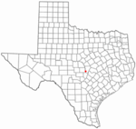
Lake Lyndon B. Johnson (more commonly referred to as Lake LBJ and originally named Lake Granite Shoals) is a reservoir on the Colorado River in the Texas Hill Country about 45 miles northwest of Austin. The reservoir was formed in 1950 by the construction of Granite Shoals Dam by the Lower Colorado River Authority (LCRA). The Colorado River and the Llano River meet in the northern portion of the lake at Kingsland.
Excerpt from the Wikipedia article Lake Lyndon B. Johnson (License: CC BY-SA 3.0, Authors, Images).Lake Lyndon B. Johnson
Wirtz Dam Road,
Geographical coordinates (GPS) Address Nearby Places Show on map
Geographical coordinates (GPS)
| Latitude | Longitude |
|---|---|
| N 30.555555555556 ° | E -98.337777777778 ° |
Address
Wirtz Dam Road
Wirtz Dam Road
78657
Texas, United States
Open on Google Maps


