place

Willingham, Cambridgeshire

Civil parishes in CambridgeshireSouth Cambridgeshire DistrictVillages in Cambridgeshire
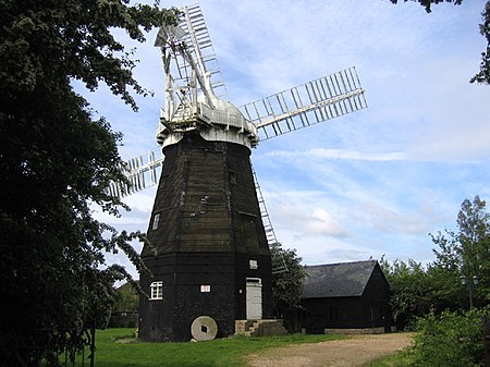
Cattell's Mill, Willingham

Willingham is a village in Cambridgeshire, England. It is located in the South Cambridgeshire district and sits just outside the border of the Fens, just south of the River Great Ouse. Located approximately 12 miles (19 km) northwest of Cambridge, on the B1050 road, Willingham Parish occupies 4,641 acres (1,878 ha), and had a population in 2007 of 3,900 people, increasing to 4,015 at the Census 2011. The highest point in the village is only approximately 23 feet (7 m) above sea level and Willingham has become increasingly at risk from flooding.

Excerpt from the Wikipedia article Willingham, Cambridgeshire (License: CC BY-SA 3.0, Authors, Images).

Willingham, Cambridgeshire
Sponge Drove, South Cambridgeshire Willingham

Geographical coordinates (GPS) Address Nearby Places
placeShow on map

Wikipedia: Willingham, CambridgeshireContinue reading on Wikipedia

Geographical coordinates (GPS)

Latitude Longitude
N 52.32 ° E 0.07 °
placeShow on map

Address

Sponge Drove

Sponge Drove
CB24 5AF South Cambridgeshire, Willingham
England, United Kingdom
mapOpen on Google Maps

Cattell's Mill, Willingham
Share experience

Nearby Places

Northstowe
Northstowe

Northstowe is a new town that will eventually have up to 10,000 homes, with an anticipated population of 24,400 in Cambridgeshire, England, UK. On 1 April 2021 Northstowe became a civil parish, the parish was formed from Longstanton and Oakington and Westwick, with the first town council elected on 6 May of that year. Northstowe has been in development for around 15 years and through varying political administrations. Originally proposed to be "an exemplar of sustainability in the use of renewable energy resources and reducing carbon emissions", Northstowe will still have many exemplar features including a Sustainable Urban Drainage Scheme (SUDS) and bus, bicycle and pedestrian only links. The Northstowe site is five miles (8 km) northwest of the city of Cambridge, between the villages of Oakington and Longstanton. The Northstowe development is being led by Homes England, the successor body to the Homes and Communities Agency, and the developers Gallagher Estates (part of L&Q).In January 2008, Yvette Cooper, Minister for Housing and Planning Department for Communities and Local Government at the time, confirmed in Parliament that Northstowe had not been adopted as an eco-town because the 2007 planning application submitted "predate[s] the eco-towns programme", and because it would not be zero-carbon.Northstowe is linked to Cambridge and St Ives by the Cambridgeshire Guided Busway which was opened in 2011.In 2012 outline consent was given to Gallagher to progress with the first phase of 1500 homes, a primary school, road improvements and a local centre. The primary school, The Pathfinder Church of England School, opened its gates to pupils in September 2017, initially taking pupils mostly from Longstanton for a year to allow redevelopment of Hatton Park Primary School. In 2015 outline consent was also agreed in principle to build a further 3,500 homes, a town centre, 3 more schools including a secondary school education campus and a link road to the A14, plus a road linking the town to the Guided Busway. The homes in phase two could not be occupied until a major A14 upgrade is completed which started in 2016 and was completed in early 2020. The first new homes at Northstowe were occupied in April 2017. In May 2020 the outline planning applications for the third and final phase were submitted for 5,000 homes, consisting of 4,000 homes on phase 3a and 1,000 homes on phase 3b.

Old Bedford River
Old Bedford River

The Old Bedford River is an artificial, partial diversion of the waters of the River Great Ouse in the Fens of Cambridgeshire, England. It was named after the fourth Earl of Bedford who contracted with the local Commission of Sewers to drain the Great Level of the Fens beginning in 1630. It provided a steeper and shorter path for the waters of the Great Ouse, and was embanked to prevent them flooding the low ground of the South Fens. Throughout the project, the Earl and his Adventurers faced disruption from those who were opposed to drainage schemes. The project was deemed to have succeeded in draining the fens in 1637, but that decision was reversed in 1638. After a lull during the English Civil War, when much of the work was damaged, the Dutch engineer Cornelius Vermuyden worked with William Russell, the fifth Earl of Bedford to complete the drainage. Disruption and unrest continued while the work was carried out, resulting in the Adventurers employing armed guards. A second river, the New Bedford River, was cut parallel to the first channel, which then became the Old Bedford River. At some point, the Old Bedford River was split into two parts, when the upper section was diverted into the River Delph at Welches Dam, and the lower section was joined to the Counter Drain. Both parts retain the name, but are not connected to each other. The area between the two Bedford rivers acts as a large washland, which holds floodwater when the river channels cannot cope with the volume of water in them. The river acts as the outlet for a number of land drainage projects. Three internal drainage boards are located along its banks, and there are several pumping stations which pump water from low-lying fens into the Counter Drain and the lower section of the Old Bedford River. At the junction with the Great Ouse is Old Bedford Sluice, through which the water passes to reach the tidal river, but this is not always possible, particularly when high volumes of water are passing down the New Bedford River as a result of heavy rainfall further up the Great Ouse. To resolve this, a pumping station was built at Welches Dam in 1948, to pump water from the Counter Drain and lower Old Bedford River into the River Delph, which runs parallel to the lower river for most of it length, but then crosses the washland to enter the New Bedford River at Welmore Lake Sluice. When pumping occurs, flow in the lower river above Welney is reversed, and a vertical sluice gate prevents water discharged into the river by the Upwell Internal Drainage Board from reaching the pumping station. The river is navigable from Welches Dam to Old Bedford Sluice, but passage through the sluice can only be made when tidal water levels allow, as there is no lock. Welches Dam Lock used to provide a link from the Middle Level Navigations to the Great Ouse, which was the only link between the two river systems when Well Creek became unnavigable. However, a campaign to save Well Creek from being filled in was successful, and the recommended transfer route follows the old course of the River Nene and Well Creek to Salters Lode Lock at Denver. In 2006, the Environment Agency closed Welches Dam Lock, and despite campaigns for it to be reinstated, it has remained closed. There are proposals as part of the Fens Waterways Link which could result in more of the Old Bedford River becoming navigable, in order to provide a circular cruising route including parts of the Great Ouse and the Middle Level Navigations.
Oakington Immigration Reception Centre

Oakington Immigration Reception Centre was an immigration detention centre located in Cambridgeshire run by UK Visas and Immigration. Originally a World War II airfield, RAF Oakington was used by RAF Bomber Command flying Short Stirling aircraft. The base contracted after the war, and much evidence of its former presence is visible in farmland surrounding the current perimeter. It was used for flight training until the 1970s, and then became a barracks. Taken over by the Home Office, it was converted to an immigration centre; in 2000 the site held and processed around 450 political asylum seekers, and between opening and mid-2005 had processed over 40,000 people who had been arrested for entering the country illegally. The site was then operated the, then, UK Border Agency's seven-day fast-track assessment process, which involved a series of interviews over an average of 14 days to determine the validity of a case. If refused asylum, detainees were removed from the country. If they gained asylum, they were released into the community.The centre received repeated criticisms from the Prisons Inspector and from others regarding safety of children and adults detained there. In January 2008, it was announced that the centre was the second worst in the country.The site was acquired in March 2006 by English Partnerships for a new town called Northstowe. The Centre was due to close in 2006 but actually closed in November 2010.