Garden Ring

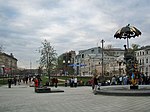
The Garden Ring, also known as the "B" Ring (Russian: Садо́вое кольцо́, кольцо́ "Б"; transliteration: Sadovoye Koltso), is a circular ring road avenue around central Moscow, its course corresponding to what used to be the city ramparts surrounding Zemlyanoy Gorod in the 17th century. The Ring consists of seventeen individually named streets and fifteen squares. It has a circumference of 16 kilometers (9.9 mi). At its narrowest point, Krymsky Bridge, the Ring has six lanes. After finishing reconstruction, all sections of the Ring will not have more than 10 lanes. In 2018, more than 50 % of sections of the Garden Ring are reconstructed, including Zubovskaya square, which was the widest section, there were about 18 lanes before. The Ring emerged in the 1820s, replacing fortifications, in the form of ramparts, that were no longer of military value.
Excerpt from the Wikipedia article Garden Ring (License: CC BY-SA 3.0, Authors, Images).Garden Ring
Садовая-Самотёчная улица, Moscow Tverskoy District
Geographical coordinates (GPS) Address Nearby Places Show on map
 Continue reading on Wikipedia
 Geographical coordinates (GPS)
| Latitude | Longitude |
|---|---|
| N 55.773611111111 ° | E 37.621666666667 ° |
Address
Самотёчная эстакада
Садовая-Самотёчная улица
127051 Moscow, Tverskoy District
Moscow, Russia
Open on Google Maps