Döhlen Basin
Basins of GermanyFreitalGeology of GermanyMining in SaxonyNatural regions of Saxony ... and 1 more
Ore Mountains stubs

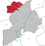
The Döhlen Basin (German: Döhlener Becken) is a landscape unit in the German federal state of Saxony, southwest of Dresden. The Döhlen Basin has a length of 22 km and a width of 6 km and lies within the district of Sächsische Schweiz-Osterzgebirge.
Excerpt from the Wikipedia article Döhlen Basin (License: CC BY-SA 3.0, Authors, Images).Döhlen Basin
Schachtstraße,
Geographical coordinates (GPS) Address Nearby Places Show on map
Geographical coordinates (GPS)
| Latitude | Longitude |
|---|---|
| N 51.00187 ° | E 13.64811 ° |
Address
Halle 106
Schachtstraße
01705 , Döhlen
Saxony, Germany
Open on Google Maps


