Gaunt's Earthcott

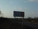
Gaunt's Earthcott, sometimes spelt Gaunts Earthcott, is a hamlet in the civil parish of Almondsbury in South Gloucestershire, England. It consists of a ruined chapel, a few houses and two farms, Green Farm and Court Farm. The village is located approximately 2.5 miles (4 km) from Rudgeway and the A38 road and about the same distance from Frampton Cotterell and Winterbourne. The village is located close to the interchange between the M4 and M5 motorways. There is no real industry as such and the main economic activity in the area is farming. Gaunt's Earthcott should not be confused with Earthcott, a couple of miles away on the B4059 road between the A38 and Yate.
Excerpt from the Wikipedia article Gaunt's Earthcott (License: CC BY-SA 3.0, Authors, Images).Gaunt's Earthcott
Gaunt's Earthcott Lane,
Geographical coordinates (GPS) Address Nearby Places Show on map
Geographical coordinates (GPS)
| Latitude | Longitude |
|---|---|
| N 51.555 ° | E -2.523 ° |
Address
Gaunt's Earthcott Lane
Gaunt's Earthcott Lane
BS32 4JR , Almondsbury
England, United Kingdom
Open on Google Maps


