Bair Island

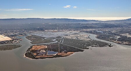
Bair Island is a marsh area in Redwood City, California, covering 3,000 acres (1,200 ha), and includes three islands: Inner, Middle and Outer islands. Bair Island is part of the larger Don Edwards San Francisco Bay National Wildlife Refuge. It is surrounded by the Steinberger slough to the northwest and Redwood Creek to the southeast. The California Department of Fish and Wildlife's Bair Island Ecological Reserve consists of 1,985 acres (803 ha) on the Middle and Outer islands, although the entire island group is managed by the Refuge. Bair Island is an important ecological wetland, which provides critical habitat for a variety of species, including the endangered California clapper rail and the Salt marsh harvest mouse, and is an important stop for birds on the Pacific Flyway. Bair Island is bisected by Corkscrew Slough, a major haul-out site for harbor seals (Phoca vitulina).
Excerpt from the Wikipedia article Bair Island (License: CC BY-SA 3.0, Authors, Images).Bair Island
Shannon Way, Redwood City
Geographical coordinates (GPS) Address Website Nearby Places Show on map
Geographical coordinates (GPS)
| Latitude | Longitude |
|---|---|
| N 37.5299362 ° | E -122.2221881 ° |
Address
Bair Island Ecological Reserve
Shannon Way
94065 Redwood City
California, United States
Open on Google Maps


