place

Spokane bombing attempt

2011 in Washington (state)Chemical weapons attacksCrimes in Washington (state)Explosions in 2011Failed terrorist attempts in the United States
History of Spokane, WashingtonJanuary 2011 events in the United StatesNeo-fascist terrorist incidents in the United StatesRacially motivated violence in the United StatesTerrorism in the United StatesTerrorist incidents in the United States in 2011
Map of Washington highlighting Spokane County

The Spokane bombing attempt occurred on January 17, 2011, when a radio-controlled shaped-charge pipe bomb was found and defused in Spokane, Washington, along the route of that year's Martin Luther King Jr. memorial march. On March 9, 2011, the Federal Bureau of Investigation (FBI) arrested Kevin William Harpham, 36, of Addy, Washington, a white supremacist who acted alone (a "lone wolf"). On December 20, 2011, he was sentenced to 32 years in prison for the attempted bombing.

Excerpt from the Wikipedia article Spokane bombing attempt (License: CC BY-SA 3.0, Authors, Images).

Spokane bombing attempt
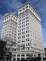
West Main Avenue, Spokane

Geographical coordinates (GPS) Address Website Nearby Places
placeShow on map

Wikipedia: Spokane bombing attemptContinue reading on Wikipedia

Geographical coordinates (GPS)

Latitude Longitude
N 47.6591 ° E -117.4181 °
placeShow on map

Address

Liberty Building

West Main Avenue
99201 Spokane
Washington, United States
mapOpen on Google Maps

Website
spokanelibertybuilding.com

linkVisit website

Map of Washington highlighting Spokane County
Share experience

Nearby Places

Riverfront Park Carousel

The Riverfront Park Carrousel, also known as the Looff Carrousel and the Natatorium Park Carousel, is a carousel in Spokane, Washington built in 1909 by Charles I. D. Looff as a gift for Looff's daughter Emma Vogel and her husband Louis Vogel, who owned Natatorium Park in Spokane. It remained at Natatorium Park until 1968 when the park closed. The carousel was then relocated to its present location at Riverfront Park in 1975 where it continues to operate. It was added to the National Register of Historic Places on September 19, 1977. The Looff still contains its original 1900 Ruth & Sohn band organ, which plays 87 key B.A.B. rolls, although due to deteriorating player rolls, a digitized recording is played during the carousel's operation. The organ was manufactured in Waldkirch, Germany and imported by Looff around 1900. The carousel contains 54 horses, one giraffe, one tiger, one goat and two chariots, all hand carved by Looff himself. It also has a ring dispenser, which allows the outside riders to grab a ring during each pass and then toss the ring at a clown with a hole for his mouth. If the rider is successful in capturing the brass ring, they can turn it in to win a free ride on the carousel.Since 1975, the carousel has been located on the south bank of the Spokane River in Riverfront Park. The park was constructed for the 1974 World's Fair, and certain structures remained in the park after the fair closed. The building that hosted a German beer garden for the fair became the new home of the carousel in the summer of 1975. As a part of a bond passed in 2014 to revitalize Riverfront Park, a new building was designed to house the carousel. The new building was designed with more space to queue and host events, and large windows to improve views of the Spokane River from the inside and views of the carousel from the outside. The new space opened in 2018.During the COVID-19 Pandemic, the Carrousel and other building amenities were closed for nearly a year. The pandemic forced a closure of the attraction on March 17, 2020, but the ride resumed operations on March 1, 2021. During the pandemic, a new ride was added when the local toy and sporting goods store founded in 1946, the White Elephant, decided to close its doors and it’s beloved white elephant ride that adorned the front entrance for decades was gifted to the city in July 2020. The elephant, known as Isidore, was formerly featured in Natatorium Park alongside the carousel and was reunited with the carousel animals in the Looff building.

Downtown Spokane

Downtown Spokane or Riverside is the central business district of Spokane, Washington. The Riverside neighborhood is roughly bounded by I-90 to the south, Division Street to the east, Monroe Street to the west and Boone Avenue to the north. The topography of Downtown Spokane is mostly flat except for areas downstream of the Spokane Falls which are located in a canyon; the elevation is approximately 1,900 feet (580 m) above sea level. Located at a traditional Native American gathering place at the Spokane Falls, American settlement was established in 1871. Most of Spokane's notable buildings, historic landmarks, and high rises are in the Riverside neighborhood and the downtown commercial district, where many of the buildings were rebuilt after the Great Fire of 1889 in the Romanesque Revival style by architect Kirtland Kelsey Cutter. After experiencing periods of decline from Post-war suburbanization, the most recent following Expo '74, the neighborhood has become revitalized after the completion of the River Park Square Mall in 1999, which has become the most prominent shopping center in the city. The chief attraction of downtown Spokane is Riverfront Park, a 100-acre (0.40 km2) park just north Spokane's downtown core, it was created after Expo '74 and occupies the same site. The park hosts some of Spokane's largest events. The neighborhood is also the center of Spokane's governmental, hospitality, convention, and cultural facilities. Mass transportation throughout downtown and the Spokane area is provided by the Spokane Transit Authority (STA) which has its STA Plaza central hub in the city center and Amtrak's Empire Builder and Greyhound operate out of the Spokane Intermodal Center. Spokane's city streets use a grid plan that is oriented to the four cardinal directions with its origin point on the east end of downtown. Sprague Avenue splits the city into North and South and Division Street divides the city into East and West. Interstate 90 (I-90) runs east–west from Seattle, through downtown Spokane, and eastward through Spokane Valley, Liberty Lake, and onward to Coeur d'Alene and then Missoula.