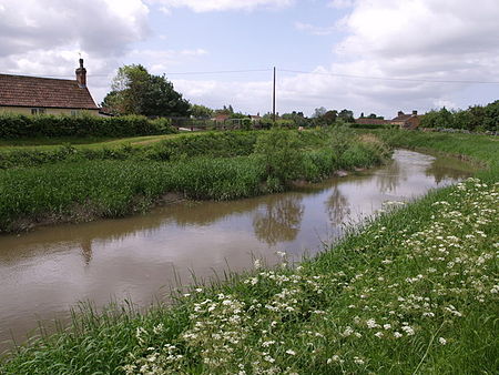
River Tone

The River Tone is a river in the English county of Somerset. The river is about 33 kilometres (21 mi) long. Its source is at Beverton Pond near Huish Champflower in the Brendon Hills, and is dammed at Clatworthy Reservoir. The reservoir outfall continues through Taunton and Curry and Hay Moors, which are designated as a Site of Special Scientific Interest. Finally, it flows into the River Parrett at Burrowbridge. An act of Parliament granted in 1699 authorised work that made the river navigable as far as Taunton. The act specified that profits should be used to benefit the poor of Taunton, but the Proprietors succeeded in avoiding their obligation until 1843, when they used the proceeds from the sale of the navigation to fund a wing of the Taunton and Somerset Hospital, and to aid the Taunton Market Trust. The Bridgwater and Taunton Canal opened in 1827, which provided an easier route than the river, and protracted legal battles followed over ownership of the river and water rights for the canal. These were not finally resolved until 1832, when the Canal Company formally took over the river navigation. The ability to navigate the river gradually deteriorated, not helped by the abandonment of the River Parrett as a navigation in 1878. Following flooding in Taunton in 1960, much of the river between there and its mouth was straightened, and the navigation locks were removed. That at Ham was blown up by the Territorial Army. Navigation rights were repealed in 1967.
Excerpt from the Wikipedia article River Tone (License: CC BY-SA 3.0, Authors, Images).River Tone
Stanmoor Bridge,
Geographical coordinates (GPS) Address Nearby Places Show on map
Geographical coordinates (GPS)
| Latitude | Longitude |
|---|---|
| N 51.067222222222 ° | E -2.9172222222222 ° |
Address
Stanmoor Bridge
Stanmoor Bridge
TA7 0RA
England, United Kingdom
Open on Google Maps


