Hafravatn
Geography of ReykjavíkLakes of IcelandPages with Icelandic IPA

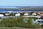
Hafravatn (Icelandic pronunciation: [ˈhavraˌvahtn̥]) is a small lake on the eastern outskirts of Reykjavík, Iceland. Located at 76 m above sea level, it has an area of 1.08 km2 (0.42 sq mi) with a greatest depth of 28 m (92 ft). The Seljadalsá River flows into it from the east and its discharge is Úlfarsá (into Korpúlfsstaðaá, also known as Ulfarsfellsa). A small village lies on the northern bank of the lake and a paragliding take-off point on its eastern side. The smaller lake of Langavatn lies to its southwest.
Excerpt from the Wikipedia article Hafravatn (License: CC BY-SA 3.0, Authors, Images).Hafravatn
Hafravatnsvegur,
Geographical coordinates (GPS) Address Nearby Places Show on map
 Continue reading on Wikipedia
 Geographical coordinates (GPS)
| Latitude | Longitude |
|---|---|
| N 64.130574 ° | E -21.662336 ° |
Address
Hafravatnsvegur
Hafravatnsvegur
270
Iceland
Open on Google Maps