place

Teufelsmauer

BallenstedtBlankenburg (Harz)Nature reserves in Saxony-AnhaltRock formations of Saxony-AnhaltRock formations of the Harz
Thale
Fotothek df ld 0003066 001 Landschaften ^ Hügellandschaften Gebirgslandschafte

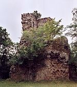
The Teufelsmauer (Devil's Wall) is a rock formation made of hard sandstones of the Upper Cretaceous in the northern part of the Harz Foreland in central Germany. This wall of rock runs from Blankenburg (Harz) via Weddersleben and Rieder to Ballenstedt. The most prominent individual rocks of the Teufelsmauer have their own names. The Teufelsmauer near Weddersleben is also called the Adlersklippen ("Eagle Crags"). Many legends and myths have been woven in order to try to explain the unusual rock formation. It was placed under protection as early as 1833 and, in 1852, by the head of the district authority in order to prevent quarrying of the much sought-after sandstone. The Teufelsmauer near Weddersleben has been protected since 1935 as a nature reserve and is thus one of the oldest nature reserves in Germany.

Excerpt from the Wikipedia article Teufelsmauer (License: CC BY-SA 3.0, Authors, Images).

Teufelsmauer
Teufelsmauerstieg,

Geographical coordinates (GPS) Address Nearby Places
placeShow on map

Wikipedia: TeufelsmauerContinue reading on Wikipedia

Geographical coordinates (GPS)

Latitude Longitude
N 51.7575 ° E 11.083055555556 °
placeShow on map

Address

Teufelsmauerstieg

Teufelsmauerstieg
06502 (Weddersleben)
Saxony-Anhalt, Germany
mapOpen on Google Maps

Fotothek df ld 0003066 001 Landschaften ^ Hügellandschaften Gebirgslandschafte
Share experience

Nearby Places

Lauenburg Castle
Lauenburg Castle

The Lauenburg is a ruined medieval castle in the East Harz in central Germany situated on an elevation southwest of the village of Stecklenberg (in the borough of Thale) in Harz district in the state of Saxony-Anhalt in the former German Democratic Republic (East Germany). The castle was built in the High Middle Ages. The ruins of the Lauenburg stand on a foothill of the Ramberg massif above the village of Stecklenberg. It was built by Henry IV and first mentioned in the records in 1164. The construction of the two-part castle with its inner and outer wards (Vorburg and Hauptburg) probably took up to ten years. The two halves of the castle are separated by a massive defensive ditch (a neck ditch or Halsgraben), hewn out of the rock. The purpose of this impressive fortification with a total length of more than 350 metres was the protection of Quedlinburg and the nearby military roads. In 1180 the Lauenburg was captured by Frederick I (Barbarossa) during a series of warlike conflicts. Later robber barons resided in the castle for periods of time, until it was destroyed in the 14th century. Today the main castle is badly run-down. Only a few remnants of the towers and the outer walls are still left. The only structure in the entire fortification that has withstood the ravages of time and history relatively well is the keep of the outer ward. Its ruins can be seen from a long way off. The Lauenburg has a checkpoint (no. 187) in the network of hiking trails that form the Harzer Wandernadel. It is on the path by the entrance to the inn that is situated between the two parts of the castle.