Rahova

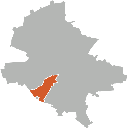
Rahova is a neighbourhood of southwest Bucharest, Romania, situated in Sector 5, west of Dâmboviţa River. It is named after the Bulgarian town Rahovo (today Oryahovo), site of a battle in the Romanian War of Independence. The neighborhood stretches from between Antiaeriană and Drumul Sării Avenues to Panduri Square (in the west), Panduri and 13 Septembrie Streets in the north, George Cosbuc Avenue, Viilor and Sălaj Streets in the east and Bucharest City Limits in the South. Roughly, the neighbourhood is organized alongside two important arterial streets (13 Septembrie and Rahovei Streets, and the streets linking them). It neighbors Drumul Taberei, Centrul Civic (at Izvor), and Ferentari. Roughly, Rahova is situated on the Uranus and Viilor hills. The inhabitants of the neighbourhood split it further in "zones", partially based on the naming and numbering of the block of flats (a specificity of Rahova is that house numbering and postal addressing is not done based on actual street numbers but rather on block numbers - a letter of the zone and an index number). As such, there are seven zones (east to west and north to south): Drumul Sǎrii (DS), Petre Ispirescu (P), Mārgeanului (M), Panduri, 13 Septembrie/Sebastian (S), Rahova (R) and Alexandriei (A). According to the Local Tax Direction of The 5th District, the population of this area is around 180,000.
Excerpt from the Wikipedia article Rahova (License: CC BY-SA 3.0, Authors, Images).Rahova
Strada Brătășanca, Bucharest Rahova
Geographical coordinates (GPS) Address Nearby Places Show on map
Geographical coordinates (GPS)
| Latitude | Longitude |
|---|---|
| N 44.398611111111 ° | E 26.055 ° |
Address
Strada Brătășanca 41
051362 Bucharest, Rahova
Romania
Open on Google Maps


