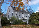
Terry's Plain Historic District

The Terry's Plain Historic District is a 325-acre (132 ha) historic district in the town of Simsbury, Connecticut that was listed on the National Register of Historic Places in 1993. The district is significant as a preserved rural landscape. It included 27 contributing buildings of various architectural styles, including Greek Revival, Federal and Late Victorian architecture, and 17 non-contributing buildings. Thirteen houses that were parts of farm complexes and 14 agricultural outbuildings ranging from sheds to large tobacco barns.Contributing sites include: A field where the militia drilled in 1683 (or 1685) 24 Ferry Lane, barn from c. 1840, house non-contributing (see #2 in photos accompanying NRHP nomination): 7 Lucius D. Goodrich House, 36 Ferry Lane, c. 1836, Federal/Greek Revival: 7 64 Terry's Plain Road, Late Victorian: 8
Excerpt from the Wikipedia article Terry's Plain Historic District (License: CC BY-SA 3.0, Authors, Images).Terry's Plain Historic District
Ferry Lane,
Geographical coordinates (GPS) Address External links Nearby Places Show on map
Geographical coordinates (GPS)
| Latitude | Longitude |
|---|---|
| N 41.883611111111 ° | E -72.784722222222 ° |
Address
Terry's Plain Historic District
Ferry Lane
06070
Connecticut, United States
Open on Google Maps


