South Newton
Civil parishes in WiltshireEngvarB from August 2019OpenDomesdayVillages in Wiltshire

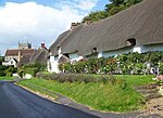
South Newton is a village and civil parish about 4 miles (6.4 km) north-west of Salisbury in Wiltshire, England. Topologically it lies between chalk downs to the north-east, and downland with Grovely Wood to the south-west. The village straddles the A36 road and is on the left bank of the River Wylye, which defines much of the western boundary of the parish; the eastern boundary follows the A360 Salisbury-Devizes road. The parish includes the village of Stoford (not to be confused with Stoford, Somerset) and the hamlets of Little Wishford and Chilhampton.
Excerpt from the Wikipedia article South Newton (License: CC BY-SA 3.0, Authors, Images).South Newton
A36,
Geographical coordinates (GPS) Address Nearby Places Show on map
Geographical coordinates (GPS)
| Latitude | Longitude |
|---|---|
| N 51.11 ° | E -1.879 ° |
Address
South Newton (towards Warminster)
A36
SP2 0QQ , South Newton
England, United Kingdom
Open on Google Maps


