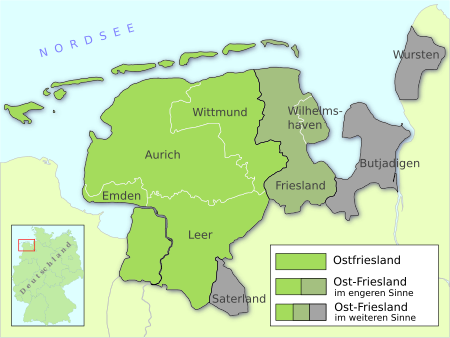
East Frisia (peninsula)

East Frisia (German: Ost-Friesland; East Frisian Low Saxon: Oost-Freesland) is a collective term for all traditionally Frisian areas in Lower Saxony, Germany, which are primarily located on a peninsula between the Dollart and the Jade Bight. Along with West Frisia and North Frisia, it is one of the most commonly used subdivisions of Frisia. It is distinct from Ostfriesland – also translated to English as "East Frisia" – which refers to a historic region that occupies the western half of the peninsula (Aurich, Leer, Wittmund and Emden). Besides Ostfriesland, East Frisia includes Landkreis Friesland and Wilhelmshaven (Oldenburger Friesland), and in a broader sense also Saterland, the Butjadingen peninsula (Rüstringen) and Land Wursten.
Excerpt from the Wikipedia article East Frisia (peninsula) (License: CC BY-SA 3.0, Authors, Images).East Frisia (peninsula)
Kreismoorstraße,
Geographical coordinates (GPS) Address Show on map
Geographical coordinates (GPS)
| Latitude | Longitude |
|---|---|
| N 53.4412 ° | E 7.6457 ° |
Address
Kreismoorstraße
Kreismoorstraße
26629
Lower Saxony, Germany
Open on Google Maps