place

South Union Street–Boardman River Bridge

Buildings and structures in Grand Traverse County, MichiganConcrete bridges in the United StatesGirder bridges in the United StatesNational Register of Historic Places in Grand Traverse County, MichiganRoad bridges in Michigan
Road bridges on the National Register of Historic Places in MichiganTransportation in Grand Traverse County, Michigan
SouthUnionStreet BoardmanRiver BridgeTraverseCityMI

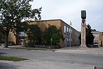
The South Union Street–Boardman River Bridge, also known as the Trunk Line Bridge, is a bridge located on South Union Street over the Boardman River in Traverse City, Michigan. It was listed on the National Register of Historic Places in 2000.

Excerpt from the Wikipedia article South Union Street–Boardman River Bridge (License: CC BY-SA 3.0, Authors, Images).

South Union Street–Boardman River Bridge
South Union Street, Traverse City

Geographical coordinates (GPS) Address External links Nearby Places
placeShow on map

Wikipedia: South Union Street–Boardman River BridgeContinue reading on Wikipedia

Geographical coordinates (GPS)

Latitude Longitude
N 44.761944444444 ° E -85.623611111111 °
placeShow on map

Address

South Union Street–Boardman River Bridge

South Union Street
49684 Traverse City
Michigan, United States
mapOpen on Google Maps

linkWikiData (Q1066854)
linkOpenStreetMap (768776052)

SouthUnionStreet BoardmanRiver BridgeTraverseCityMI
Share experience

Nearby Places

TART Trail

The Traverse Area Recreational Trail (TART Trail) is a rail trail in Michigan and is part of U.S. Bicycle Route 35. It is a paved, non-motorized recreational trail of 10.5-mile (16.9 km) in length that extends from the west side of Traverse City (M-22) to Acme (M-72). Most, but not all, of the trail follows the 19th-century roadbed of the former Chicago and West Michigan Railway. The trail intersects other non-motorized trails in greater Traverse City, including the Boardman Lake Trail that skirts Boardman Lake, the Leelanau Trail with a connection to Suttons Bay, and the Vasa Pathway, a system of loop trails constructed for cross-country skiing and other non-motorized recreational use in the Pere Marquette State Forest east of Traverse City. The original TART Trail was constructed in 1991–95. It was enlarged and extended several times in 1995–2005. Eventually the trail will connect to the Little Traverse Wheelway, but for now segment 1 is being worked out to connect to Elk Rapids. Segment 2 between Lautner and Bates roads has no completion time, while segment 1 on is in a preliminary planning phase from Elk Rapids to Bates Road. Points of interest along the trail include: The shoreline of Grand Traverse Bay Clinch Park along the downtown bay-front Downtown Traverse City Traverse City State Park Traverse City Area District Library Beaches Hotels, Restaurants and Resorts Local and regional transportation (Bay Area Transportation Authority) TART in Town (on-street bike route) Darrow Park F&M ParkThe trail's acronym "TART" pays tribute to one of the best-known agricultural products of the Traverse City area, the tart cherry or pie cherry. For similar reasons, the local airport is called Cherry Capital Airport.