Mūkupurvs

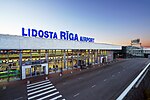
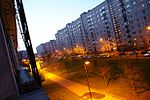
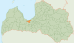
Mūkupurvs is a neighborhood of the city of Riga, the capital city of Latvia and in Pārdaugava, a suburb of Zemgale. Mūkupurva neighborhood is located in the R part of Riga. It borders Beberbekai, Zolitūde and Pleskodāle neighborhoods, as well as Mārupe parish of Mārupe county, which is adjacent to the D part of Mūkupurva neighborhood. The boundaries of the Mūkupurva neighborhood are a line parallel to Beberbeķu line 5, Krotes iela, a line along the residential massif, the city boundary (Babītes iela, Kalnciema iela) and Kārļa Ulmanias gatve. The total area of Mūkupurva neighborhood has a population of 242, and its area 4,515 km2, which is only slightly less than the average area indicator of Riga neighborhoods. Currently, this neighborhood is a very underdeveloped area of Riga, but judging by its location and configuration, it can be created and function as a unified neighborhood in the future. Along the perimeter, the length of the boundary of Mūkupurva neighborhood is 10,293 meters. The D part of Mūkupurva neighborhood, which is also the border of the city of Riga, is adjacent to the territory of the Riga International Airport.
Excerpt from the Wikipedia article Mūkupurvs (License: CC BY-SA 3.0, Authors, Images).Mūkupurvs
Siekātes iela, Riga Mūkupurvs
Geographical coordinates (GPS) Address Nearby Places Show on map
 Continue reading on Wikipedia
 Geographical coordinates (GPS)
| Latitude | Longitude |
|---|---|
| N 56.9383 ° | E 23.9808 ° |
Address
Siekātes iela
Siekātes iela
LV-1053 Riga, Mūkupurvs
Vidzeme, Latvia
Open on Google Maps