place

Budna

Bedfordshire geography stubsHamlets in BedfordshireNorthill

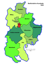
Budna is a hamlet in the civil parish of Northill, in Bedfordshire, England. Budna is located to the north of the village of Northill, and near to Thorncote Green and Hatch. Budna lies on the border between Central Bedfordshire and the Borough of Bedford.

Excerpt from the Wikipedia article Budna (License: CC BY-SA 3.0, Authors).

Geographical coordinates (GPS)

Latitude Longitude
N 52.11652 ° E -0.32513 °
placeShow on map

Address

Budna Road

Budna Road
SG19 1PX
England, United Kingdom
mapOpen on Google Maps

Share experience

Nearby Places

Ickwell Bury
Ickwell Bury

Ickwell Bury, at the heart of the former manor of Ickwell, Bedfordshire, was first built by John Harvey in 1683 near the site of an older manor house. The Harvey family continued to own the house until 1925, although from 1900 it had housed Horton Preparatory School.In 1898, Ickwell Bury was the property of John Edmund Audley Harvey DL JP and was described as "a mansion of red brick, in the Queen Anne style, standing in a park and woodlands of about five hundred acres, approached by an avenue of trees about a mile in length".The school closed in 1937, and soon afterwards most of the empty house was destroyed in a fire, though a 17th-century wing with its Thomas Tompion clock were saved. The property was then bought by Colonel George Hayward Wells, chairman of the brewery Charles Wells, who rebuilt the house on a smaller scale and on his death left the Ickwell Bury estate to the Bedford Charity to be used by Bedford School, his own old school. The school uses the grounds for field studies and as a conservation reserve, and for a number of years Ickwell Bury (the house) was rented from the school by the Yoga for Health Foundation and was open all year round. It was especially busy during the summer months where all the rooms were open and tents covered the grounds around the main house. In 1999 Bedford School sold Ickwell Bury and its garden - it is now a private house - and in 2013/14 it sold the remaining 47 hectares of farmland, a cottage, and (with planning permission for conversion to homes) the listed barns of Home Farm. In a wood between Ickwell Bury and Northill church is an ancient earthwork, with a high bank on the east side, enclosing long pools which are thought to have been fish ponds for the monks of a college at Northill or for the priory of Ickwell Bury.

Beeston, Bedfordshire

Beeston is a hamlet of about 530 acres (2.1 km2) in the town of Sandy in the Wixamtree hundred of the county of Bedfordshire, England, about a half a mile south of Sandy, north of Biggleswade and east of Bedford. Beeston appears in the Domesday Book of 1086 where it shown as having a mill: "Bistone: Roland, Norman and Pirot from Eudo FitzHubert; William Speke; Thurstan the Chamberlain; Godmund; Alwin from the King. Mill." The medieval period saw the construction of the Great North Road, the post road connecting London to Edinburgh, which ran through Beeston. In the 1930s the Ministry of Transport upgraded the Great North Road to a trunk road and it became the A1 in 1923. Subsequent upgrades during the 1960s saw this section of the road become a dual carriageway which effectively split the hamlet and isolated the larger part of Beeston from Sandy, pedestrian access being limited to a footbridge. Plans are afoot to reposition the road to bypass Beeston/Sandy but no date for this work has been set. Historically the main occupation of the residents of Beeston was market gardening, farming and straw plaiting (woman & girls) for the hat industry.Beeston is in the Anglican Parish of St Swithun, Sandy. It has a Wesleyan (Methodist) Chapel built 1865 with seating for 300. A former chapel on Beeston Green is now a private home. The major feature of Beeston is the 13-acre (53,000 m2) village green bounded by many of the older residences.