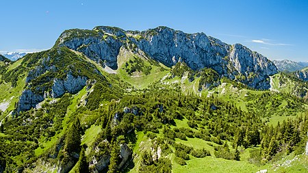
Benediktenwand
Bad Tölz-WolfratshausenBavarian PrealpsMountains of BavariaMountains of the AlpsOne-thousanders of Germany

The Benediktenwand (formerly the Kirchstein) is a 1,800-metre-high (5,900 ft) mountain ridge in the Bavarian Prealps between the rivers Loisach and Isar and the Jachenau in the south and Benediktbeuern Abbey, from which it derives its name, in the north. Immediately below the North Face of the Benediktenwand is the Tutzinger Hut (1,327 m). During the Würm glaciation, the summit of the Benediktenwand towered about 600 metres above the ice stream of the Walchensee and Isar Glaciers (branches of the Inn Valley Glacier).
Excerpt from the Wikipedia article Benediktenwand (License: CC BY-SA 3.0, Authors, Images).Benediktenwand
Maxisteig, Benediktbeuern (VGem)
Geographical coordinates (GPS) Address Show on map
Geographical coordinates (GPS)
| Latitude | Longitude |
|---|---|
| N 47.65306 ° | E 11.46556 ° |
Address
Maxisteig (Maxlsteig)
Maxisteig
83671 Benediktbeuern (VGem)
Bavaria, Germany
Open on Google Maps