Römerstein (mountain)

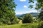
Römerstein is a mountain of Baden-Württemberg, Germany. It lies on a plateau, whose highest point is 874 metres (2,867 ft) above sea level. The municipality of Römerstein in the district of Reutlingen, in which territory it lies, is named after it. Although the Romans in Donnstetten(Clarenna) settled immediately east of the mountain between AD 85-260, the name is not derived from them but from the name of the family Rem, which was established in the 14th Century in the region. The forested crest of the hill rises an average of only about 70 metres above its immediate surroundings, but due to its location (near the northwest Albtrauf, above the deep Lenninger Lautertal and by the falling south plateau) it offers excellent visibility.
Excerpt from the Wikipedia article Römerstein (mountain) (License: CC BY-SA 3.0, Authors, Images).Römerstein (mountain)
Böhringer Straße, Römerstein
Geographical coordinates (GPS) Address Nearby Places Show on map
Geographical coordinates (GPS)
| Latitude | Longitude |
|---|---|
| N 48.51 ° | E 9.5436111111111 ° |
Address
Böhringer Straße
72587 Römerstein
Baden-Württemberg, Germany
Open on Google Maps


