place

Monte Misma

Lombardy geography stubsMountains of LombardyMountains of the Alps
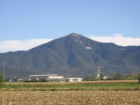
Misma01
Misma01

Monte Misma is a mountain of Lombardy, Italy. It is located within the Bergamasque Prealps.

Excerpt from the Wikipedia article Monte Misma (License: CC BY-SA 3.0, Authors, Images).

Monte Misma
Sentiero della val Calchera,

Geographical coordinates (GPS) Address Nearby Places
placeShow on map

Wikipedia: Monte MismaContinue reading on Wikipedia

Geographical coordinates (GPS)

Latitude Longitude
N 45.735 ° E 9.8191666666667 °
placeShow on map

Address

Croce del Monte Misma

Sentiero della val Calchera
24069
Lombardy, Italy
mapOpen on Google Maps

Misma01
Misma01
Share experience

Nearby Places

Pradalunga
Pradalunga

Pradalunga (Bergamasque: Prédalónga) is a comune (municipality) in the Province of Bergamo in the Italian region of Lombardy, located about 60 kilometres (37 mi) northeast of Milan and about 11 kilometres (7 mi) northeast of Bergamo. As of 31 December 2006, it had a population of 4,460 and an area of 8.39 square kilometres (3.24 sq mi).The municipality of Pradalunga contains the frazione (subdivision) Cornale. Pradalunga borders the following municipalities: Albino, Cenate Sopra, Nembro, Scanzorosciate. Pradalunga has many hills and mountains: the most important mountain in Pradalunga is “Mount Misma“. The Serio River crosses Pradalunga, so Pradalunga is in the Seriana Valley. On Mount Misma there is a sanctuary. Its name is “Forcella” and it is dedicated to the Virgin Mary. It was built by miners. Next to the sanctuary there is a restaurant. The patron saints of Pradalunga and Cornale are Saint Lucy, Saint Christopher, Saint Vincent and Saint Barbara. Saint Lucy brings presents to the children in the night of every 13 December. Pradalunga and Cornale's people pray a lot for them. There are three churches dedicated to the patron saints; some local streets are named for them. Saint Barbara is the patron of every miner. Miners are very important for the economy of Pradalunga because in this village there are the quarries of the “Coti” stones; from these quarries miners used to extract the “Coti” stones. These stones are typical of Pradalunga and they are used to sharpen knives, scissors and so on. They are exported to many foreign countries.

San Paolo d'Argon
San Paolo d'Argon

San Paolo d'Argon (Bergamasque: San Pól d'Àrgon) is a comune (municipality) of 5,721 inhabitants in the Province of Bergamo in the Italian region of Lombardy, located about 60 kilometres (37 mi) northeast of Milan and about 11 kilometres (7 mi) east of Bergamo. The commune is located at the beginning of the Cavallina Valley and it's crossed by two main roads: the Strada Statale 42 del Tonale e della Mendola and the Provincial Road 91 to the Lake Iseo. It is home to a large Cluniac monastery, founded in 1079. It was restored in the 16th century, as shown by the perfectly geometrical Renaissance cloisters (1500 and 1532). In the former refectory there are frescoes (1624) by Giovanni Battista Lorenzetti. The annexed church, dedicated to the Conversion of Saint Paul, was rebuilt between 1684 and 1690 on an ancient romanesque one and represents one of the most impressive examples of Baroque architecture in Bergamo. Its white façade in local marble dates back to 1690. The single wide nave's vault is completely decorated with frescoes by Giulio Quaglio (1712–13). Three little chapels open up on the two sides of the nave. Other artworks include canvasses by Giuseppe Maria Crespi, Sebastiano Ricci and Antonio Balestra. The bell tower was rebuilt in 1738 as reported on its eastern side too. Until the early 20th century, the town was known as Buzzone, while the name "San Paolo d'Argon" designed the monastic complex. From 1929 to 1948 San Paolo d'Argon was united with the neighbouring villages of Cenate Sotto and Cenate Sopra forming a single commune called Cenate d'Argon.