Newtonville, Ontario
Designated places in OntarioGolden Horseshoe geography stubsNeighbourhoods in Clarington

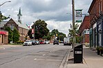
Newtonville is a dispersed rural community in the Municipality of Clarington, Durham Region, Ontario, Canada. It is located about 30 kilometres (19 mi) east of Oshawa and about 10 kilometres (6.2 mi) west of Port Hope on the former Highway 2. Newtonville is the most easterly community in Clarington (and in Durham Region), and therefore forms the eastern end of the Greater Toronto Area. The community was formerly part of the southeastern part of the township of Clarke until 1973.
Excerpt from the Wikipedia article Newtonville, Ontario (License: CC BY-SA 3.0, Authors, Images).Newtonville, Ontario
Newtonville Road, Clarington
Geographical coordinates (GPS) Address Nearby Places Show on map
 Continue reading on Wikipedia
 Geographical coordinates (GPS)
| Latitude | Longitude |
|---|---|
| N 43.939166666667 ° | E -78.4925 ° |
Address
Our Convenience Store
Newtonville Road
Clarington
Ontario, Canada
Open on Google Maps